Wismar Bay
The Wismarer bay (also Wismarbucht ) as part of the Mecklenburg Bay is after further west Luebeck Bay the southern branch of the Baltic Sea . It is located in front of West Mecklenburg ( Mecklenburg-Western Pomerania )
geography
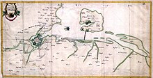
The Hanseatic city of Wismar is located at its southeastern tip . It is bounded to the west by the Klützer Winkel and to the northeast by the island of Poel . In the east of the bay is the small island of Walfisch , formerly part of the city fortifications of Wismar . To the west lies the Boltenhagen Bay .
The Wismar Bay is divided into several sub-bays:
Maritime transport
The concrete entrance from Kiel-Ostsee-Weg and Lübeck-Gedser-Weg to the port of Wismar runs through the Wismar Bay as a federal waterway . To the west of the fairway lies the flat area of the Lieps . From this fairway, the fairway branches off to the island of Poel. In front of the Wendorfer Ufer are two duck albums with baroque Swedish heads . Today they are reminiscent of the earlier form of the fairway designation and today no longer have any navigational significance for shipping .
natural reserve
The Wismar Bay is a diverse marine habitat, which with its coastal areas , which are often still subject to natural dynamics, is of great importance for numerous animal and plant species. It fulfills the protected area categories of European importance and is accordingly designated as an FFH and bird protection area Wismarbucht . In 2006 a comprehensive management plan was drawn up to coordinate the interests of fishing and water sports , fishing and nature conservation . The five nature reserves NSG Tarnewitzer Huk , NSG Walfisch , NSG Fauler See - Rustwerder / Poel , NSG Langenwerder and NSG Rustwerder are located in the Wismar Bay .
literature
- Management plan for the FFH area DE 1934-302 Wismar Bay. (PDF) Environment Ministry Mecklenburg-Western Pomerania, 2006, p. 132 , accessed on June 9, 2009 .
Web links
Individual evidence
- ^ Dataset German National Library
- ↑ Bird world of the Wismar Bay ( Memento from March 11, 2011 in the Internet Archive )
Coordinates: 53 ° 57 ′ 0 ″ N , 11 ° 27 ′ 0 ″ E


