Lindisfarne (island)
| Lindisfarne | ||
|---|---|---|
| Lindisfarne Castle | ||
| Waters | North Sea | |
| Geographical location | 55 ° 40 '41 " N , 1 ° 47' 44" W | |
|
|
||
| surface | 4 km² | |
| Residents | about 160 (2013) 40 inhabitants / km² |
|
| main place | Holy Island Village | |
| View of Lindisfarne Bay | ||

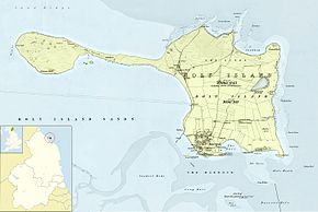
Lindisfarne , also known as Holy Island , is a tidal island in England on the northeast coast of Northumberland . A large part of the island as well as the intertidal zone is a bird sanctuary . Up to 300 species of birds, both migratory and native birds , can be observed here. Lindisfarne is connected to the coast by a road that is only passable at low tide .
In the 7th century the Irish monk St. Aidan founded Lindisfarne Monastery on Holy Island . On June 8, 793, Lindisfarne was attacked by Scandinavian Vikings . This raid marks the beginning of the Viking Age . Only ruins of the Benedictine monastery built in the 11th century can be visited.
On a steep hill are the ruins of Lindisfarne Castle , which was built around 1540 to protect the harbor against Scottish attacks. The ruin was converted into a private house in 1903.
The Holy Island Waggonway consisted of three interconnected narrow gauge railways for the transport of limestone that were in operation from 1846 to 1883.
On March 27, 2011, 180 inhabitants were counted.
Web links
Individual evidence
- ^ Roger C. Jermy: Northern Northumberland's Minor Railways: Volume 4: Limestone Industry Lines . The Oakwood Press, Catrine, Ayrshire 2012, ISBN 978-0-85361-706-8 , Locomotion Papers 234D. P. 25 and 31.
- ^ Holy Island Ward population 2011


