List of natural monuments in Diemelstadt
The list of natural monuments in Diemelstadt called in Diemelstadt in Waldeck-Frankenberg in Hesse located natural monuments . They are protected according to Sections 28, 22 of the Hessian Law on Nature Conservation and Landscape Management and Section 12 of the Hessian Implementation Act for the Federal Nature Conservation Act.
| image | designation | District, location | description | Art | No. |
|---|---|---|---|---|---|
|
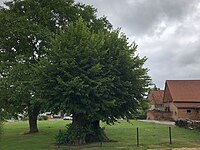
Linden tree | Ammenhausen 51 ° 26 '44.2 " N , 9 ° 2' 55" E |
Bizarre, hollow linden tree in a playground area. | Linden tree | 07 001 |
| Lean grassland "The Vineyard" | Ammenhausen 51 ° 26 '47.3 " N , 9 ° 3' 37.2" E |
Rough grass east of Ammenhausen. | Grasslands | 07 002 | |
| Virgin beech | Rhoden 51 ° 28 '15.7 " N , 8 ° 59' 5.5" E |
Hutebuche approx. 2 km west of Rhoden as a remnant of the original Hutewald. | beech | 07 003 | |
| Sessile oak | Rhoden 51 ° 28 ′ 16.7 " N , 9 ° 2 ′ 35.5" E |
Particularly striking solitary tree on the edge of the forest. | Sessile oak | 07 004 | |
| 2 beeches | Rhoden 51 ° 28 ′ 35.5 " N , 9 ° 2 ′ 38.8" E |
Two old beech trees northeast of Hof Laubach. | beech | 07 005 | |
| Laubacher hat | Rhoden 51 ° 28 ′ 45.2 " N , 9 ° 2 ′ 6.9" E |
1.94 hectares of semi-arid grassland about 1.2 km northeast of Rhoden. | 07 006 | ||
| "Kulike" wetland | Rhoden 51 ° 27 ′ 21.9 " N , 9 ° 0 ′ 30.6" E |
1.93 hectares of marshland approx. 1 km south of Rhoden. | 07 007 | ||
 more pictures |
Flat moor meadow "Salzborn" | Rhoden 51 ° 29 ′ 2.1 " N , 8 ° 59 ′ 37.4" E |
1.4 hectares of flat moorland west of Rhoden. | 07 008 | |
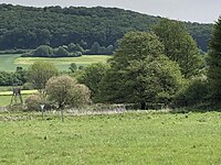
| Lean lawn with hat trees | Rhoden 51 ° 28 ′ 26.2 " N , 9 ° 2 ′ 25.1" E |
1.04 hectares of poor grassland with hat trees southeast of Laubach. | 07 009 | ||
 more pictures |
Marsh area "The lazy break" | Rhoden 51 ° 29 ′ 7.2 ″ N , 9 ° 1 ′ 15 ″ E |
1.2 hectares of swamp area with pond, large sedge and wooded areas northeast of Rhodes. | Swamp area | 07 010 |
|
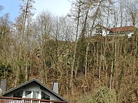
Sandstone rocks at the "Flüburg" | Rhoden 51 ° 28 ′ 49.5 " N , 9 ° 0 ′ 23.8" E |
1.8 hectares below the fire station and two houses to the west. Black striped fern, also hardwood and worm fern; Protection of the rock section opposite to the west. | 07 011 | |
| "Fingerwiese" wetland | Rhoden 51 ° 28 ′ 16.3 " N , 8 ° 58 ′ 1.8" E |
1.13 hectares west of Rhoden, east of the Denkelhof. Marsh flora with irises, spawning area of the fire salamander, wet areas and rivulets. | Swamp area | 07 012 | |
|
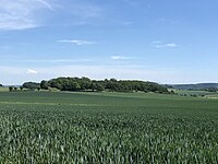
"Hessenbühl" | Wethen 51 ° 29 '3.9 " N , 9 ° 4' 11.9" E |
1.71 hectares on the southern slope of the Hessenbühl. Semi-arid lawn with occurrences of tuberous sweet, orchids, bee orchis and pyramid orchid. | 07 013 | |
|
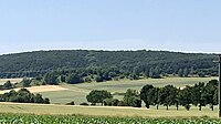
"Hohe Hegge" | Wethen 51 ° 29 ′ 22.2 " N , 9 ° 3 ′ 26.2" E |
1.65 hectares approx. 1 km west of Wethen. Dry grass flora on shell limestone. | 07 014 | |
 more pictures |
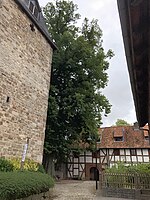
Church linden tree | Wethen 51 ° 29 ′ 30.4 " N , 9 ° 4 ′ 37.9" E |
Old church linden tree next to the church. | Linden tree | 07 015 |
See also
Web links
Commons : Natural monuments in Diemelstadt - collection of images
supporting documents
- ↑ Appendix 1 to the Ordinance on the Protection of Natural Monuments in the Waldeck-Frankenberg District. (pdf; 374 kB) Waldeck-Frankenberg district, March 18, 2013, accessed on January 24, 2016 .
- ^ Ordinance on the protection of natural monuments in the Waldeck-Frankenberg district. (pdf; 1.42 MB) Waldeck-Frankenberg district, March 18, 2013, accessed on January 24, 2016 .
- ↑ Details 07 001
- ↑ Details 07 002
- ↑ Details 07 003
- ↑ Details 07 004
- ↑ Details 07 005
- ↑ Details 07 006
- ↑ Details 07 007
- ↑ Details 07 008
- ↑ Details 07 009
- ↑ Details 07 010
- ↑ Details 07 011
- ↑ Details 07 012
- ↑ Details 07 013
- ↑ Details 07 014
- ↑ Details 07 015