
Llastres
| Colunga municipality: Parroquia Lastres | |||
|---|---|---|---|
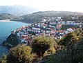
 View from the harbor to the village of Llastres
|
|||
| coat of arms | Map of Spain | ||

|
|
||
| Basic data | |||
| Autonomous Community : |
|
||
| Comarca : | Oriente | ||
| Coordinates | 43 ° 31 ′ N , 5 ° 16 ′ W | ||
| Area : | 13.49 km² | ||
| Residents : | 1.012 (2011) INE | ||
| Population density : | 75.02 inhabitants / km² | ||
| Postal code : | 33675 | ||
| Area code: | 33019050000 | ||
| Nearest airport : | Asturias airport | ||
| administration | |||
| Address of the municipal administration: | Plaza del Ayuntamiento nº 1 - 33320 Colunga | ||
| Location of the municipality | |||

|
|||

Llastres is a settlement (parish or Parroquia ) in the municipality of Colunga in the Spanish province of Asturias .
The place has a total area of 13.49 km² and in 2011 had 1012 inhabitants. Llastres is located directly on the Cantabrian Sea .
Districts
- Llastres
- Lluces 185 inhabitants 2011
Attractions
- Capilla de San Roque - picturesquely located chapel
- Faro de Llastres - lighthouse on the cliff

from the west

by sea

the lighthouse

Capilla de San Roque


swell
- Population figures see INE
- Postcodes see [1]
- For coordinates and heights, see Google Earth
Web links
Commons : Llastres - collection of images, videos and audio files