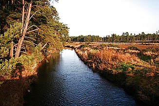
Lossie
| Lossie | ||
|
The Lossie four kilometers southeast of Lossiemouth |
||
| Data | ||
| location | Moray , Scotland | |
| River system | Lossie | |
| source | on the slopes of Carn Kitty 57 ° 28 ′ 39 ″ N , 3 ° 30 ′ 1 ″ W |
|
| muzzle | at Lossiemouth in the Moray Firth Coordinates: 57 ° 43 ′ 11 " N , 3 ° 16 ′ 45" W 57 ° 43 ′ 11 " N , 3 ° 16 ′ 45" W.
|
|
| length | 50 km | |
| Right tributaries | Leanoch Burn | |
The Lossie is a river in Scotland . It is created by the confluence of several source streams in the sparsely populated highlands of Moray on the slopes of Carn Kitty . There is a distance of 31 km between the source and the mouth. Its course, however, has a length of 50 km, which reflects the meandering course of the Lossie. On the upper reaches, the river takes in various mountain streams and overcomes several rapids . The Lossie initially flows primarily in a north-easterly direction and then turns to the north. He passes the small town of Dallasand from this point follows a north-east or north direction again. The river reaches Elgin where the A96 trunk road crosses it. Shortly before its confluence with the Moray Firth at Lossiemouth , the Lossie takes on the Spynie Canal and Innes Canal .
Like most rivers in the region, the Lossie burst its banks in the flood events of 1829. Numerous bridges crossing the river were destroyed.
Individual evidence
- ↑ a b Entry in the Gazetteer for Scotland
- ↑ a b Lossie. In: Francis H. Groome: Ordnance Gazetteer of Scotland: A Survey of Scottish Topography, Statistical, Biographical and Historical. Volume 5: (Lib - Pet). Thomas C. Jack, Grange Publishing Works, Edinburgh et al. 1884, p. 558 .
