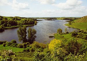
Lough Gur
| Lough Gur | |
|---|---|

|
|
| View over Lough Gur | |
| Geographical location | County Limerick , Republic of Ireland |
| Drain | → Camoge River → River Maigue |
| Data | |
| Coordinates | 52 ° 30'51 " N , 8 ° 32'1" W |

|
|
| Grange stone circle | |
Lough Gur ( Irish Loch Goir ) is a lake in the Irish County Limerick , near the town of Bruff . It is shaped like a horseshoe and extends at the feet of Knockadoon Hill. The area around the lake is one of the most important archaeological sites in Ireland. The area has been inhabited for more than 6000 years.
The most important of the 28 objects around the lake are menhirs and the remains of Beehive-huts and Duns (Carraig Aille) as well as:
- The great stone circle at Grange is the largest in Ireland, around 45 meters in diameter. The stones are up to 2.8 meters high.
- Remains of at least three crannógs (artificial islands) in the lake.
- Remains of two houses from early Christian times. Because of their outline, they are called The Spectacles .
- Wedge Tombs on Lough Gur like "Leaba na Muice" and "Giant's Grave" as megalithic systems , from the 3rd millennium BC.
- The bronze shield from Lough Gur
At the northeast corner of the lake is the Lough Gur Interpretive Center , which exhibits models and finds from the area.
At the other end of the lake is Black Castle, a refuge during the Desmond Rebellions . Possibly this was the place where the Earl of Desmond changed his English for Irish clothes after his return from London in 1573, thus increasing his reputation among the locals.
See also
literature
- Peter Harbison : Pre-christian Ireland - From the first Settlers to the early Celts . London 1970 ISBN 0-500-27809-1 pp. 154-155
- Seán Ó Riordáin: Lough Gur Excavations: Carraig Aille and the “Spectacles” In: Proceedings of the Royal Irish Academy. 52, C, 3 (Dublin: Hodges, Figgis 1949), p. 72 ff
Web links
- Shannon Heritage's Lough Gur homepage ( Memento of November 3, 2012 in the Internet Archive )
- Lough Gur Wedge tomb (Engl.)
- Lough Gur Wedge tomb (Engl.)
- Leaba na Muice (Eng.)
