M'Sila
|
المسيلة ⵎⵙⵉⵍⴰ M'Sila |
||
|---|---|---|
|
|
||
| Coordinates | 35 ° 42 ' N , 4 ° 33' E | |
| Basic data | ||
| Country | Algeria | |
| M'Sila | ||
| ISO 3166-2 | DZ-28 | |
| Residents | 132,975 (2008 Census) | |
|
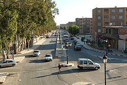
Cityscape
|
||
M'Sila ( Arabic المسيلة, DMG al-Masīla , tamazight ⵎⵙⵉⵍⴰ) is the capital of the province of M'Sila in the north of Algeria with 132,975 inhabitants (as of 2008).
history
M'sila was the first village to be built using local materials as part of a government program to relocate the Algerian nomads to a settled life. The completed village was named Maader and consists of houses, public areas, trading zones and a mosque. Today it has become a modern metropolis with many companies, business offices, religious centers and schools.
climate
According to the Köppen and Geiger climate classification , M'Sila has a cold, semi-arid climate (BSk). The average annual temperature is 15.8 degrees Celsius. About 229 mm of precipitation falls annually.
Population development
| Census year | population |
|---|---|
| 1977 | 33,642 |
| 1987 | 65,805 |
| 1998 | 102.151 |
| 2008 | 132.975 |
Individual evidence
- ↑ M'Sila climate: average temperature, weather by month, M'Sila weather averages - Climate-Data.org. Retrieved May 16, 2020 .
- ↑ Algeria: Provinces & Cities - Population Statistics, Maps, Charts, Weather, and Web Information. Retrieved May 16, 2020 .

