Mäanderhöhle (Lower Austria)
| Meander Cave
|
||
|---|---|---|
|
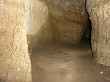
The cave entrance |
||
| Location: | in Eulenberg near Kirchberg am Wechsel | |
| Height : | 655 m above sea level A. | |
|
Geographic location: |
47 ° 37 '3.5 " N , 15 ° 58' 51.7" E | |
|
|
||
| Cadastral number: | 2871/14 | |
| Geology: | Triassic lime | |
| Type: | Rift cave | |
| Overall length: | 28 m | |
| Level difference: | 2 m (+2 m) | |
The Mäanderhöhle with the cadastral number 2871/14 is a cave near Kirchberg am Wechsel in Lower Austria .
General
The in the low mountain relief of the Bucklige Welt at an altitude of 655 m above sea level. A. lying cleft cave is 28 m long and has a height difference of +2 m. It is located in the Middle Triadic limestone of the Eulenberg ( Eigenberg ), where the better known Hermannshöhle (2871/07) is also located. A few meters south of the Mäanderhöhle is the entrance of the longer Anton Cave (2871/02).
Course
A few meters after the three meter high and 1.2 meter wide entrance, the corridor tapers to 1 × 0.5 meters. This meanders, following a left curve to a right curve, towards the south-southwest. Then it goes slightly uphill further west, whereby the corridor becomes higher again. At the end a narrow stretch branches off to the south with a few side niches, but they are all too narrow to continue.
literature
- Max H. Fink, Helga and Wilhelm Hartmann: The caves of Lower Austria . Ed .: Regional Association for Speleology in Vienna and Lower Austria. tape 1 . Vienna 1979, p. 254 .


