Müllergraben
| Müllergraben | ||
|
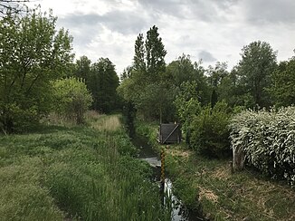
Müllergraben south of the B 246 |
||
| Data | ||
| Water code | DE : 5828656 | |
| location | Germany , Brandenburg | |
| River system | Elbe | |
| Drain over | Notte → Dahme → Spree → Havel → Elbe → North Sea | |
| Headwaters | Meadow area north of Waldstadt 52 ° 11 ′ 49 ″ N , 13 ° 28 ′ 0 ″ E |
|
| muzzle | north of the city center of Zossen in die Notte Coordinates: 52 ° 13 ′ 30 ″ N , 13 ° 27 ′ 40 ″ E 52 ° 13 ′ 30 ″ N , 13 ° 27 ′ 40 ″ E
|
|
| length | 3.4 km | |
| Catchment area | 25.16 km² | |
| Small towns | Zossen | |
The Müllergraben is a left tributary of the Notte in Brandenburg .
The ditch begins in a meadow north of the Zossen district of Waldstadt and there north of the Gerlachshof road , which runs in a west-east direction. The Müllergraben runs from there around 1000 meters in a northerly direction and crosses under the Grüner Weg . In the further course it branches off slightly to the northwest and after around 1095 meters reaches the federal highway 246 . Behind the main road it runs around 245 meters to the northwest, then branches off to the northeast and finally drains into the Notte in a meadow .
Individual evidence
- ↑ a b River directory gewnet25 (Version 4.0, April 24, 2014) at the Ministry for Rural Development, Environment and Agriculture of the State of Brandenburg, accessed on June 14, 2019.
