
Mafinga Hills
| Mafinga Hills | ||
|---|---|---|
| Highest peak | Mafinga ( 2339 m ) | |
| location | Malawi / Zambia border | |
|
||
| Coordinates | 10 ° 0 ′ S , 33 ° 12 ′ E | |
| particularities | highest point of Zambia | |

The Mafinga Hills , also Mafinga Mountains , are a south-north-running, approximately 100-kilometer-long mountain range east of the upper Luangwa Valley in the extreme northeast of Zambia on the border with Malawi , into which it extends. They are part of the watershed between Luangwa and Lake Malawi , which runs south over the Nyika Plateau and the highlands of the Viphya Mountains . Its highest peak, the Mafinga (after Mark Horrell also Mafinga Central ⊙ ), reaches 2339 m and lies on the border with Zambia. The border follows the watershed in this area . The second highest peak is the Namitawa ( ⊙ ) with 2164 m , which is 25 kilometers southeast of Chitipa also on the border with Zambia.
East of Isoka there are the Mafinga Falls of a source river of the Luangwa . They are very difficult to reach because of the very difficult, rocky, if not dangerous terrain through dense thickets and a 25-kilometer walk from the village of Mpangala on the Luangwa.
On the eastern Malawian side is the Mafinga Hills Forest Reserve . It covers an area of 4734 ha and was placed under protection in 1976.
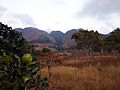
Mafinga Hills of Chisenga from
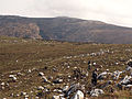
Summit of the Mafinga


Individual evidence
- ↑ a b Mark Horrell: Mafinga South and Mafinga Central: the highest peaks in Zambia. September 24, 2014, accessed November 18, 2014 .
- ↑ Mafinga Central on Peakbagger.com (English)
- ↑ Daulos DC Mauambeta (WESM), David Chitedze (Greenline Movement), Reginald Mumba (CURE), Stella Gama (Department of Forestry): Status of Forests and Tree Management in Malawi. August 2010, accessed December 30, 2015 .