Nyika plateau
| Nyika plateau | ||
|---|---|---|
|
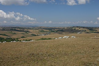
Typical landscape of the central Nyika plateau |
||
| Highest peak | Nganda ( 2607 m ) | |
| location | Malawi , Zambia | |
|
|
||
| Coordinates | 10 ° 21 ′ S , 33 ° 36 ′ E | |
The Nyika Plateau is a highland in northwest Malawi on the border with Zambia . It separates two trenches of the Rift Valley system, the Luangwa Valley in the west and Lake Malawi in the east. Depending on the definition of the borders, the Nyika covers between 1,800 and 3,300 km², of which 70 km² is on Zambian territory. About half of the area is at an average altitude between 2100 and 2500 meters above sea level and is therefore in the afromontane zone .
geography
Nyika has hardly been developed and has been largely uninhabited for many millennia. Agricultural or forestry use takes place only in the border areas of the plateau, on the damp eastern slopes and to a limited extent in the forest plantation of Chelinda. Despite the forestry use at Chelinda ( ⊙ ) in the heart of the plateau, the Nyika plateau was considered a white spot on the map of Malawi until the middle of the 20th century. It was not until 1949 that large parts of the area were explored and mapped on behalf of the British government by an expedition led by Laurens van der Post .
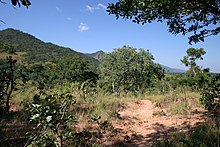
While Miombo forests predominate in the lower areas , the central area of the plateau consists of rolling grassland with damp valleys and waterlogging depressions, so-called dambos , into which smaller areas with submontane or afromontane evergreen forest are interspersed. Characteristic for this landscape are on the one hand the regularly occurring bush fires as well as the heavy rainfall and the resulting landslides on the hill flanks. During the fire in the drier areas, the encroachment prevents the wet dambos and the more profound Rutschungsbereiche provide sufficient protection from the bush and grass fires and foster small-scale in areas of higher growth trees and the training of evergreen mountain forests. Occasionally the mosaic of grasslands and forests is interrupted by larger granite mountains or quartzite blocks . However, steeper breaks only occur at the break edges in the north and east. The highest peaks of the plateau are the Nganda with 2607 m ( ⊙ ) in the north of the plateau and the Kasaramba with 2460 m ( ⊙ ) in the southeast.
In 1966 the core of Nyika was established as the "Malawi National Park" and expanded to include the peripheral areas in the 1970s. Today, the Nyika National Park with its 3143 km² includes not only the central plateau but also the escarpment and the range of hills in the northeast and south, making it Malawi's largest national park.
climate
Due to its altitude, the Nyika plateau has very cool temperatures compared to the rest of the country. The average daily minimum at Chelinda fluctuates between 11 degrees in June and 16 degrees in December, but in winter it is not uncommon for night frosts with temperatures well below zero to occur. The maximum daily temperatures are relatively stable and are between 17 and 20 degrees over the year. Occasionally the temperatures rise to 26 degrees in summer.
With its year-round and overall very high rainfall, the Nyika is one of the most important rainfall areas in Malawi. Often the entire higher Nyika plateau lies under a blanket of fog and cloud that extends to the ground. The annual precipitation is between 1000 and 2000 mm with emphasis on the east and west flanks of the plateau and a slightly lower precipitation (annual mean 1500 mm) in the center. Locally, however, significantly lower precipitation is measured in the shadow of the larger elevations and in the north of the plateau (<1000 mm).
Hydrology
The large amount of precipitation accumulates in the Dambos, from which four noteworthy rivers develop, the Northern Rukuru , the Northern Rumphi , the Chelinda-Rumphi and the Runyina , which all drain to the east into Lake Malawi , sometimes forming spectacular waterfalls. These rivers form the essential basis for the water supply of northern Malawi.
The only natural standing water on the plateau is Lake Kaulime near Chelinda, which was likely dammed by a landslide . In addition, there are two smaller artificial reservoirs that were created for the forest plantation near Chelinda. Due to the high rainfall and the prevailing vegetation typical of tropical highlands, acid found in the region of the plateau predominantly huminstoffreichen Latosole with a pH of 5.5. Due to the continuously high water level in the Dambos and the low temperatures, the organic matter only breaks down slowly. The soils are poor in nutrients, acidic and peat formation takes place.
Flora and fauna
Although the wide grassy areas with the occasionally interspersed woods suggest an anthropogenic influence at first glance, studies of the history of flora show that the landscape that dominates today has been dominant since the last ice age over 12,000 years ago.
Four predominant plant communities can be distinguished. With around 60% of the total area of the park, the Miombo dry forest represents the largest plant community, but is limited to low and medium-sized areas. The predominant genus here is Brachystegia . The loose tree population reaches a height of 10 and 20 m in lower areas, dwarfism occurs in medium to higher areas and the height of growth only reaches 3 m.
The afromontane grassland , which is actually so typical for Nyika, comprises only 30% of the total area, but predominates in the central plateau area. It essentially consists of up to 90 small grass species with herbaceous species interspersed with them, as well as isolated bushes.
Evergreen submontane and montane forests have the smallest share of the total area with 3%. Particularly noteworthy are the forests of the montane areas of the high plateau scattered on the dambos, landslide areas and fire-protected areas , as well as a larger Juniperus procera population located in the southeast of Chelinda , whose distribution, in contrast to the other forests, is promoted by fire.
With its abundance of plants and the varied landscape, the Nyika Plateau is one of the great centers of diversity in Africa with regard to the biodiversity of the flora . The most recent survey by SANBI in 2005 identified almost 1900 species in 680 genera and 160 families. The north, east and west foothills of the plateau were not taken into account, so that the actual number of species is likely to be significantly higher. With only 33 endemic species, mostly perennial plants and geophytes , the Nyika Plateau has a comparatively low endemism rate.
The Nyika National Park offers various species of antelope ( sable antelope , horse antelope , eland , bushbuck , duiker and red hartebeest ), zebras , warthogs and a variety of birds. The predators include hyenas , large numbers of leopards and some small species of big cats. There is also a small population of African wild dogs in the peripheral areas . Lions or big game such as elephants , rhinos or buffalo are missing or can only be found in the low-lying peripheral areas (e.g. Vwaza Marsh Game Reserve ).
tourism
Although the Nyika plateau is free of malaria and tsetse due to its high location and cool temperatures , it is largely undeveloped for tourism. This is due on the one hand to the remoteness of the area, which is too far away from the centers of Lilongwe and Blantyre to serve as a local recreation area, but on the other hand to the lack of infrastructure. Apart from a privately run luxury lodge by Nyika Safaris and a simple campsite near Chelinda , as well as a hut on the Zambian side, the park does not offer any tourist facilities. There are no supply options. The simple and sparse network of trails is also passable for normal vehicles when dry, but due to the frequent rainfall, all-wheel drive is recommended, especially during the rainy season. It is not possible to travel from Zambia. Air Malawi offers a more or less regular flight service to Chelinda (12 seater Cessna). Nyika Safaris offer horse riding and hiking tours in the park, but mountain bike trips are also possible.
literature
- Willis C. Burrows (Ed.): Plants of the Nyika Plateau . SANBI Report No. 31, 2005.
- R. Knapp: The vegetation of Africa . Gustav Fischer Verlag, 1973.
- M. Meadows: Late Quaternary Vegetation History of the Nyika Plateau, Malawi . In: Journal of Biogeography 11, 1984.
- M. Meadows: Dambos and Environmental Change in Malawi, central Africa . In: Zeitschrift für Geomorphologie 52, 1985.
- L. van der Post: Venture to the Interior . 1952.
Web links
- Nyika-Vwaza-Trust - Homepage - (accessed December 18, 2009)
- Official website (Zambia)


