Luangwa
|
Luangwa Rio Aruângua |
||
|
The catchment area of the Luangwa |
||
| Data | ||
| location |
|
|
| River system | Zambezi | |
| Drain over | Zambezi → Strait of Mozambique | |
| source | near Isoka , Zambia | |
| muzzle | near Zumbo (Mozambique) in the Zambezi Coordinates: 15 ° 37 ′ 12 ″ S , 30 ° 25 ′ 16 ″ E 15 ° 37 ′ 12 ″ S , 30 ° 25 ′ 16 ″ E |
|
| Mouth height |
327 m
|
|
| length | 806 km | |
| Catchment area | 159,615 km² | |
| Discharge at gauge PZ 17 (1) A Eo : 147,622 km² at the mouth |
MNQ 1963-1992 MQ 1963-1992 Mq 1963-1992 MHQ 1963-1992 |
61 m³ / s 688 m³ / s 4.7 l / (s km²) 2010 m³ / s |
| Left tributaries | Matizye, Msandile, Crocodile River, Lukusuzi, Lumimba, Lundazi, Vumbo | |
| Right tributaries | Lunsemfwa , Lusiwasi, Kapamba, Kalete, Luwi, Mwamba, Mupamedzi, Mutinondo , Mwaleshi River, Mansha | |
| Residents in the catchment area | 1,817,000 (as of 2005-06) | |
|
The Luangwa in South Luangwa National Park |
||
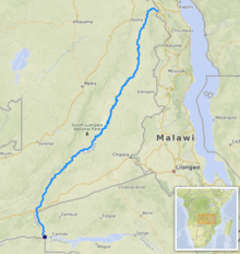
The Luangwa (Portuguese: Rio Aruângua ) flowing in southern Africa is an 806 km long left tributary of the Zambezi in Zambia .
course
The water-rich river rises in the high border mountains of Zambia and Malawi west of the northern end of Lake Malawi , the Mafinga Hills , the foothills of the Poroto Mountains and the northern Muchinga Mountains near Isoka . However, it turns away from this lake in order to flow in a south-westerly direction through eastern Zambia. The river winds through the inaccessible, hardly populated, wide and high-lying lowlands of the North Luangwa National Park and the Luambe National Park through the South Luangwa National Park . Its catchment area is given with values between 160,000 and 148,000 km².
In its lower reaches it forms the border to Mozambique and flows into the Zambezi at Zumbo , almost 80 km further south at the border triangle Mozambique-Zambia- Zimbabwe .
At Mporokoso there is another river in Zambia, called the Luangwa, which is visited for the Mumbuluma Falls .
Hydrology
The flow rate of the catchment area of the river was measured at the mouth in m³ / s.

geography
Long stretches of the Luangwa Valley are surrounded by high rock walls, making it impassable in most places in an east-west direction. The difference in height between the peaks and the valley floor is up to a thousand meters, especially in the northern part of the river. To the east and west of the valley there is a road in north-south direction at a large distance.


