
Maga dam
| Maga dam | |||||||
|---|---|---|---|---|---|---|---|
 |
|||||||
|
|||||||
|
|||||||
| Coordinates | 10 ° 48 ′ 0 ″ N , 14 ° 57 ′ 0 ″ E | ||||||
| Data on the structure | |||||||
| Construction time: | until 1979 | ||||||
| Height of the barrier structure : | 10 m | ||||||
| Crown length: | 25 km | ||||||
| Data on the reservoir | |||||||
| Water surface | 360 | ||||||
| Reservoir length | 25 km | ||||||
| Reservoir width | 7 km | ||||||
| Storage space | 680 Mm³ (max.); 280 Mm³ (min.) | ||||||
| Catchment area | 6th 000 km² | ||||||

The Maga Reservoir is a reservoir in Cameroon .
location
The lake is located in the province of Extrême-Nord directly on the border with Chad , approx. 150 km south of N'Djamena . The dam is 25 km long and borders the town of Maga , which is located directly to the north of the lake.
use
The dam was commissioned in 1979 by the SEMRY organization to create an irrigation system for growing rice. For this, a branch of the Logone was dammed in the floodplain of the river and the river was diked in its further course. It soon became apparent, however, that economic success was largely absent.
ecology
The ecological consequences of the dam are serious. In the further course of the original floodplain is the Waza National Park , which is affected by the structure. Therefore, in 1994, the dam was opened on a trial basis to check the regenerative capacity of the ecosystem.
The lake is an important refuge for waterfowl in the dry season.
gallery
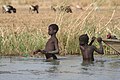
Children fishing in Lake Maga.

Return from fishing.

Hippos in Lake Maga.
.jpg)

