Maiki Hill
The Maiki Hill , better known as the Flagstaff Hill , is a 98 meter high hill in the Northland on the North Island of New Zealand . It is north of Russell (formerly Kororareka ). The hill is a destination for many tourists visiting Russell. There are hiking trails up the hill which offers expansive views over the Bay of Islands . Kiwis live in the bush around the hill .
Role in Flagstaff War
The hill is known for its role in the early stages of the Flagstaff War , the first major clash between the Māori and Europeans. Māori from the Iwi of the Ngāpuhi faced the British colonial power, European settlers ( Pākehā ) and allied Māori.
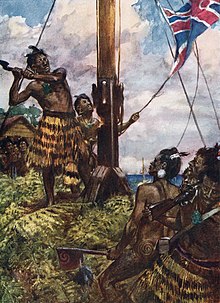
On the hill was a flagpole of the British colonial power with the Union Jack hoisted. This mast was felled four times by the Māori during the war: on July 8, 1844 by Te Haratua, on January 10, 1845 by Hone Heke , on the night of January 18 to 19, 1845 again by Hone Heke and that last time on April 11, 1845. The British did not re-erect the flagpole after the war.
Today's flagpole
The current flagpole was erected in January 1858 on the initiative of Te Ruki Kawiti's son Maihi Paraone Kawiti . The flag on it was christened “Whakakotahitanga” (“to be one with the queen”). As a further symbolic act, 400 Ngāpuhi warriors were selected from the armed forces of the "rebels" who fought in the Flagstaff War for the preparation and erection of the mast. The Ngāpuhi of the Hapū of Tāmati Wāka Nene , who had been allied with the British in the war, were allowed to watch the construction, but not take part in it. The re-erection of the flagpole was described by Maihi Paraone Kawiti as a voluntary act of the Ngāpuhi, who felled it in 1845. You wouldn't allow anyone else to help.
Individual evidence
- ↑ Melina Goddard: Flagstaff Hill Historic Reserve - Maiki Hill . (PDF; 1 MB) Department of Conservation , 2011, accessed on February 23, 2016 .
- ^ A b Hugh Carleton: The Life of Henry Williams . tape II . Early New Zealand Books (ENZB), 1874, pp. 328-331 (English, auckland.ac.nz ).
Coordinates: 35 ° 15 ′ 20 ″ S , 174 ° 7 ′ 15 ″ E


