Maiviken
| Maiviken | ||
|---|---|---|
|
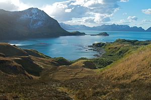
View of the Maiviken with Camp Peak (left) and Rocky Point (right of the center of the picture) |
||
| Waters | Cumberland Bay | |
| Land mass | South Georgia | |
| Geographical location | 54 ° 14 ′ 46 ″ S , 36 ° 30 ′ 21 ″ W | |
|
|
||
Maiviken is a small bay at the northern end of the Thatcher Peninsula in Cumberland Bay on the north coast of South Georgia . Your entrance is between Rocky Point in the west and Mai Point in the east.
It was mapped during the Swedish Antarctic Expedition (1901–1903) under the direction of Otto Nordenskjöld . It was named after the May day in 1902, on which expedition participants sailed the bay. The original name Majviken changed to the Norwegian spelling over the years.
Web links
- Maiviken in the Geographic Names Information System of the United States Geological Survey (English)
- Maiviken on geographic.org (English)

