Makaro / Ward Island
| Makaro / Ward Island | ||
|---|---|---|
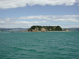
| East side of the island as seen from the Wellington Harbor Ferry | ||
| Waters | Wellington Harbor , South Pacific | |
| Geographical location | 41 ° 17 '41.4 " S , 174 ° 52' 17.2" E | |
|
|
||
| length | 250 m | |
| width | 80 m | |
| Highest elevation | 20 m | |
| Residents | uninhabited | |
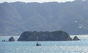
| West side of the island with beacon | ||
Makaro / Ward Island is an island in the south of Wellington Harbor near Wellington in New Zealand . It is located in the approach to the port between the Miramar Peninsula in the west and Eastbourne, about 2 km to the east, on the east coast of the port. The much larger island Matiu / Somes Island is about 5 km north.
According to Māori legend , the islands of Matiu and Makaro got their original names from Kupe , the legendary first navigator who returned to his native Hawaiki with reports about New Zealand . He is said to have named the islands after his daughters (other versions of the legend speak of nieces) when he first entered Wellington Harbor about 1000 years ago.
The island was officially given the bilingual name Makaro / Ward Island by the New Zealand Geographic Board .
The main mass of the island consists of a steeply sloping block of yellowish-brown argillite (a talc schist) with a flattened surface. The east coast of the island consists of greywacke rubble. The rest of the coastline is rocky. Two small sandy beaches on the west coast are in front of the approximately 20 meter high cliffs. The coast, especially the south end, is surrounded by numerous small rocky reefs.
The main fairway of the port approach runs west of Ward Island. The sea area east between Ward and Eastbourne, however, is too shallow for larger ships. There is a beacon off the west coast.
The island was already used in the early 19th century by Māori of the Ngati Ira as a place of retreat in times of war ( Pā ), which was not permanently inhabited as a retreat. Since the island with its steep cliffs already offered protection, no fortifications had to be built.
During the Second World War, a 1.8 km long submarine barrier made of wooden stakes was built between Robinson Bay near Eastbourne and the east coast of the island, and a barrier net anchored to buoys continued from the west side of the island to Kau Point on the west side the port approach. Only a few concrete blocks remain on the west side of the island.
The island is popular with pleasure boats, the rocky coast is used for fishing and snorkeling. Ward Island is classified as a Science Sanctuary by the DOC , so camping, campfires, and dogs are not allowed.
The island is home to a small population of seagulls and other sea birds that nest on the steep slopes. Otherwise the island is uninhabited. At the southern end of the island there are fields of aquatic plants that are home to numerous fish and edible mussels such as paua and green-lipped mussel .
In order to prevent rodents from settling, the DOC has been operating bait stations on the island since 2005, which contain pellets with the active ingredient Brodifacoum .
The Street Makaro in Eastbourne is named after the island, the western end of her can be seen from.
Individual evidence
- ↑ David Hamer, Roberta Nicholls: The making of Wellington, 1800-1914-ll essays. Victoria University Press 1990
- ^ Ann Carew, Allison Carew: Eastbourne, a history of the eastern bays of Wellington harbor. Eastbourne Historical Society Inc. 2001
- ^ A b Peter Cooke: Defending New Zealand - ramparts on the sea 1840 - 1950s. Defense of New Zealand Study Group 2000
- ↑ a b DOC Wellington Conservancy 2005 Pesticides report ( Memento of September 30, 2007 in the Internet Archive ) accessed on April 1, 2007
- Topographic map series NZTOPO50 sheet BQ32 567 268


