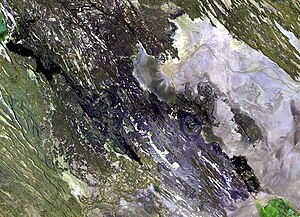
Manda Hararo
| Manda Hararo | ||
|---|---|---|
| height | 600 m | |
| location | Ethiopia | |
| Coordinates | 12 ° 10 '12 " N , 40 ° 49' 12" E | |
|
|
||
| Last eruption | 2009 | |
The Manda Hararo is a 105 km × 30 km volcanic complex in Ethiopia . It is located in the south of the Afar area in the Kalo plain and southeast of the Dabbahu .
Most recently, high activity in the area was noted in mid-2009. Among other things, this was associated with the emission of sulfur dioxide and lava .
construction
At the northern end of the complex is a small basaltic shield volcano . To the south of this volcano there is a large area covered by cracks in the ground and lava flows. Two other shield volcanoes, the larger of which is called Unda Hararo , are in the center of the complex. Even further to the south is the Gumatmali-Gablaytu area, which is characterized by numerous soil cracks that are oriented to the northwest. South of this area you can find lava flows and solidified lava lakes . The southeast end of the complex is formed by the Gablaytu Shield Volcano .
Individual evidence
- ↑ David J. Ferguson, Talfan D. Barnie, David M. Pyle, Clive Oppenheimer, Gezahegn Yirgu: Recent rift-related volcanism in Afar, Ethiopia . In: Earth and Planetary Science Letters . tape 292 , no. 3-4 , April 2010, pp. 409-418 , doi : 10.1016 / j.epsl.2010.02.010 ( elsevier.com [accessed August 4, 2019]).
- ↑ a b Global Volcanism Program | Manda Hararo. Accessed August 4, 2019 .
- ^ Sennert, SK: Report on Manda Hararo (Ethiopia) . In: Global Volcanism Program (Ed.): Weekly Volcanic Activity Report . 8 July-14 July 2009. Smithsonian Institution and US Geological Survey, 2009.

