
Manganese-ji (Tochigi)

The manganese-ji ( Japanese 満願寺 ), also Izuru Kannon ( 出流観音 called), the mountain name Izuru-san ( 出流山 ) is a temple of Shūchisan branch ( 宗智山派 Shūchisan-ha ) of the Shingon direction of Buddhism in the mountains in the Izuru-machi district on the northeastern edge of the city of Tochigi , Japan. In the traditional census it is the 17th of the 33 temples in the Kantō region .
history
According to tradition, the temple was created in the 3rd year Tempyō-Jingo (767) by priest Shōdō ( 勝 道 ). He was once visited by the traveling priests ( 修 験 者 shugensha ) of Nikkō . In 1609, Minagawa Hiroteru, who had been deposed, withdrew there. Shogun Tokugawa Iemitsu supplied the temple with 50 koku .
The attachment
You enter the temple complex through the large temple gate ( 山門 Sammon ), which is designed here as a tower gate in the style of a Niō gate ( 仁王 門 Niō-mon ), i.e. as a gate with the two temple guards to the right and left of the passage. The gate was built in 1735 and is registered as a cultural asset of the city of Tochigi. The main hall ( 本 堂 Hondō ) above, also called Ōmidō ( 大 御堂 ) here , dates from 1764. It is registered as a cultural asset of the prefecture.
The temple includes the Oku-no-in ( 奥 の 院 ), a more than 4 m high narrow building that was built up in the mountains in front of a rock wall. It is built on a steep slope over long support pillars. On the way to the Oku-no-in you pass the Daihi ( 大悲 'Great Mercy' ) waterfall, from where you can get to the Oku-no-in via a staircase with more than a hundred steps.
The temple includes a bell tower ( 鐘楼 Shōrō ), an abbot and monk's quarters, a guest house and other buildings.
photos

Temple gate

Oku-no-in
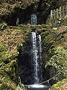
Daihi waterfall


Remarks
- ↑ Minagawa Hiroteru ( 皆川 広 照 ; 1558-1628) was a general and daimyo who ruled over large areas in the northern area of the Kanto plain. He was deposed by the shogunate in a family dispute.
literature
- Tochigi-ken no rekishi sampo henshū iinkai (ed.): Mangan-ji . In: Tochigi-ken no rekishi sampo. Yamakawa Shuppan, 2008. ISBN 978-4-634-24609-6 . Pp. 217, 218.
Web links
Coordinates: 36 ° 28 ′ 31.9 " N , 139 ° 35 ′ 21.3" E