
Martinsufer
| Martinsufer | |
|---|---|
|
|
|
 |
|
| Kaiser Wilhelm Bridge and Martinsufer | |
| Basic data | |
| place | trier |
| District | center |
| Connecting roads | Zurlaubener Ufer , Ascoli-Piceno-Straße, Katharinenufer |
| Cross streets | Lindenstrasse , Merianstrasse, Kaiser-Wilhelm-Brücke , Ausoniusstrasse |
| Places | Georg-Schmitt-Platz |
| Buildings | Kaiser Wilhelm Bridge , Martinskloster |
The Martinsufer is a street on the edge of Trier city center in the district of Mitte / Gartenfeld . It runs along the Moselle at the level of the Kaiser Wilhelm Bridge . In the north, the car-free Zurlaubener Ufer and the main thoroughfare, the Ascoli-Piceno-Strasse , join as the riverside road, and the Katharinenufer in the south . With seven lanes for motor vehicles, the Martinsufer is one of the widest streets in Trier: two lanes lead from the Kaiser-Wilhelm-Brücke to the south, two from the Ascoli-Piceno-Straße to the south, two from the Katharinenufer to the north; the seventh lane serves as a left-turn lane in two sections. The Martinsufer is part of the federal highway 49 .
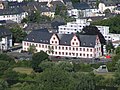
The name is derived from the Martinskloster , which is located on the street and is now used as a student residence .
Cultural monuments
Cultural monuments on the Martinsufer are the former Benedictine Abbey of St. Martin and the officers' houses from the 1920s in the Merianstrasse / Martinsufer monument zone

Martinskloster and view along Martinsufers to the north
Moselle, Martinsufer, Martinskloster

Monument zone Merianstrasse / Martinsufer


literature
- Patrick Ostermann (arrangement): Cultural monuments in Rhineland-Palatinate. Monument topography Federal Republic of Germany. Volume 17.1: City of Trier. Old town. Werner, Worms 2001, ISBN 3-88462-171-8
- Ulrike Weber (edit.): Cultural monuments in Rhineland-Palatinate. Monument topography Federal Republic of Germany. Volume 17.2: City of Trier. City expansion and districts. Werner, Worms 2009, ISBN 978-3-88462-275-9 .
- General Directorate for Cultural Heritage Rhineland-Palatinate (publisher): Informational directory of cultural monuments of the district-free city of Trier. (PDF; 1.2 MB) Koblenz 2010.
- Kulturbüro der Stadt Trier (ed.) / Emil Zenz: Street names of the city of Trier: their sense and their meaning. Trier 2003.
Individual evidence
- ↑ Kulturbüro der Stadt Trier (ed.) / Emil Zenz: Street names of the city of Trier: their sense and their meaning. Trier, 2003.
- ↑ General Directorate for Cultural Heritage Rhineland-Palatinate (ed.): Informational directory of cultural monuments in the district-free city of Trier. (PDF; 1.2 MB) Koblenz 2010.
Coordinates: 49 ° 45 ′ 45.8 ″ N , 6 ° 38 ′ 0.8 ″ E