
Matauri Bay (bay)
| Matauri Bay | ||
|---|---|---|
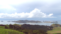
 Panorama of Matauri Bay. In the center of the picture the southernmost islands of the Cavalli Islands. |
||
| Waters | Pacific Ocean | |
| Land mass | Northland Peninsula , North Island , New Zealand | |
| Geographical location | 35 ° 2 ′ 7 ″ S , 173 ° 55 ′ 19 ″ E | |
|
||
| width | approx. 2 km | |
| depth | approx. 1 km | |
| Islands | Cavalli Islands | |

Matauri Bay is a bay in the Far North District on New Zealand's North Island . It is located 30 km north of Kerikeri , north of the Bay of Islands . The Cavalli Passage separates the bay from the northeastern Cavalli Islands .
The bay has a white sandy beach over a kilometer long and is therefore particularly popular in summer by campers at the campsite at the northern end of the bay. You can surf, dive and fish in Matauri Bay.
The small village of Matauri Bay is located on the bay.
Some of the first Polynesian immigrants landed in Matauri Bay. It was the site of early contacts between the Māori and the Europeans, for example with the missionary Samuel Marsden in 1814.
Wreck of the Rainbow Warrior
The ship of Greenpeace Rainbow Warrior (see sinking of the Rainbow Warrior ), sunk by French secret service agents with the approval of then President François Mitterrand in 1985 by a terrorist bombing, found its final resting place as an artificial reef in the Cavalli Islands near Matauri Bay. The idea came from the New Zealand Underwater Association . It seemed a fitting end for a ship that had been protecting the marine environment all its life. A memorial above the beach is dedicated to the Rainbow Warrior.
The ship was patched, lifted and towed north from Auckland on December 2, 1987. Ten days later the ship received a traditional Māori burial. Today the wreck is a popular diving destination. The local Māori take care of its protection and preservation.

Memorial to the Rainbow Warrior
Cavalli Islands. The far right cape is the north end of Matauri Bay

Matauri Bay Beach


