Maupertuis (moon crater)
| Maupertuis | ||
|---|---|---|

|
||
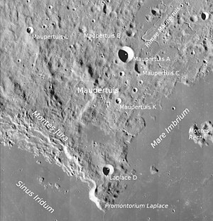
| Maupertuis and surroundings ( LROC -WAC) | ||
|
|
||
| position | 49.65 ° N , 27.34 ° W | |
| diameter | 44 km | |
| depth | 1350 m | |
| Card sheet | 11 (PDF) | |
| Named after | Pierre Louis Moreau de Maupertuis (1698-1759). | |
| Named since | 1935 | |
| Unless otherwise stated, the information comes from the entry in the IAU / USGS database | ||
Maupertuis is an impact crater in the northwest of the front of the moon . The very heavily eroded crater is located in mountainous, strongly rugged terrain in the Montes Jura northeast of the Sinus Iridum . To the southeast lies the Mare Imbrium plain and to the south the Promontorium Laplace . To the east beyond the Maupertuis A secondary crater is a system of fractures, the Rimae Maupertuis .
| Letter | position | diameter | link |
|---|---|---|---|
| A. | 50.65 ° N , 24.78 ° W | 14 km | [1] |
| B. | 51.35 ° N , 26.78 ° W | 6 km | [2] |
| C. | 50.27 ° N , 24.11 ° W | 10 km | [3] |
| K | 49.32 ° N , 25.13 ° W | 5 km | [4] |
| L. | 51.33 ° N , 29.26 ° W | 6 km | [5] |
The crater was officially named by the IAU in 1935 after the French mathematician Pierre Louis Moreau de Maupertuis .
Web links
- Maupertuis in the Gazetteer of Planetary Nomenclature of the IAU (WGPSN) / USGS
- Maupertuis on The-Moon Wiki
Individual evidence
- ^ John E. Westfall: Atlas of the Lunar Terminator. Cambridge University Press, Cambridge et al. 2000, ISBN 0-521-59002-7 .
