Mbam (river)
| Mbam | ||
|
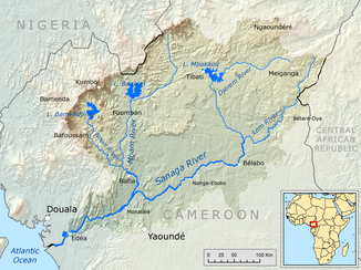
Catchment area of the Sanaga with the Mbam (middle slightly left) |
||
| Data | ||
| location |
|
|
| River system | Sanaga | |
| Drain over | Sanaga → Bay of Bonny | |
| origin | Confluence of several headwaters in the Adamaua highlands 7 ° 5 ′ 23 ″ N , 11 ° 59 ′ 33 ″ E |
|
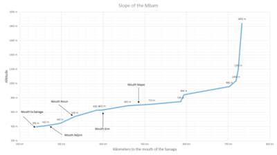
| Source height | 1850 m | |
| muzzle | at Ebebda in the Sanaga coordinates: 4 ° 23 ′ 8 ″ N , 11 ° 16 ′ 17 ″ E 4 ° 23 ′ 8 ″ N , 11 ° 16 ′ 17 ″ E |
|
| Mouth height | 395 m | |
| Height difference | 1455 m | |
| Bottom slope | 2.9 ‰ | |
| length | 494 km | |
| Catchment area | about 42,500 km² | |
| Discharge at the Goura A Eo gauge: 42,300 km² Location: 20 km above the mouth |
NNQ (min. Month Ø) MNQ 1951/1980 MQ 1951/1980 Mq 1951/1980 MHQ 1951/1980 HHQ (max. Month Ø) |
43 m³ / s 133 m³ / s 710 m³ / s 16.8 l / (s km²) 1914 m³ / s 2570 m³ / s |
| Left tributaries | Kim ; Ndjim | |
| Right tributaries | Mapé ; Noun | |
|
The mouth of the Mbam (left) in the Sanaga |
||
The Mbam is a river in Cameroon .
course
It is the largest tributary of the Sanaga and flows into it at Ebebda . Its headwaters are in the Adamaua highlands . From there it flows south. With a length of 494 km it drains an area of about 42,500 km².
discovery
Probably the first European to reach the Mbam was Kurt Morgen in 1889. He named him Kaiser Wilhelm River. However, this name did not catch on in Cameroon during the German colonial era.
Hydrometry
The flow rate of the river was measured for 29 years (1951–1980) at the Goura gauge, about 20 km above the mouth in m³ / s.

Individual evidence
- ↑ a b c PDF on the hydrology of Cameroon (French) Accessed July 25, 2018
- ↑ a b c d GRDC Station Information, Station: Goura
- ↑ C. Morgen: Through Cameroon from South to North: Travel and Research in the Hinterland, 1889 to 1891
Web links
Commons : Mbam River - collection of images, videos and audio files


