Medny (island)
| Medny | ||
|---|---|---|
| NASA image of Medny in winter | ||
| Waters | Bering Sea | |
| Archipelago | Commander Islands | |
| Geographical location | 54 ° 40 ′ N , 167 ° 44 ′ E | |
|
|
||
| length | 59 km | |
| width | 7 km | |
| surface | 186 km² | |
| Highest elevation | Gavanskaya 640 m |
|
| Residents | uninhabited | |
| main place | Preobrazhenskoye (abandoned) | |
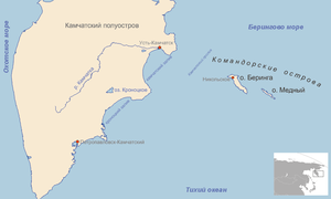
| Map of the commanders' islands off Kamchatka, Medny (east) | ||
Medny ( Russian о́стров Ме́дный / ostrow Medny ; Medny Island , translated Copper Island ) is the second largest island of the commanders' islands after Bering Island .
geography
The 186 km² island is 59 km long and between 5 and 7 km wide, narrower in the southeast part. The highest point gora Gawanskaja ( гора́ Гава́нская , in German about "harbor mountain") is in the northwest part of the island and has a height of 640 m . At the north-western end of the island are the beaver rocks ( Бобро́вые ка́мни / Bobrowyje kamni ), which are connected to the island by an isthmus about 1 km in length.
The former capital Preobrazhenskoe ( Преображе́нское ) has been abandoned.
The average temperature is about +2.8 the year ° C .
history
The island was discovered by Vitus Bering in 1741 on the Second Kamchatka Expedition , also known as the Great Nordic Expedition . On the uninhabited island, the Preobrazhenskoe settlement was founded at the end of the 19th century by the Aleutians who originally lived on the island of Attu .
In 1970 all of Medny's residents were relocated to the neighboring Bering Island. The island, which is now uninhabited again, serves as an object of study for researching the Arctic flora and fauna .
Sea otters , walruses and arctic foxes are native to the island .
Web links
- Brief information and pictures (English)
- Medny ( Memento from December 23, 2010 in the Internet Archive ) on Oceandots.com (English)


