Menhir of Bucha
| Menhir of Bucha The pointed stone | ||
|---|---|---|
|
Menhir of Bucha |
||
|
|
||
| Coordinates | 51 ° 23 '21.1 " N , 13 ° 3' 58.6" E | |
| place | Cavertitz , Saxony , Germany | |
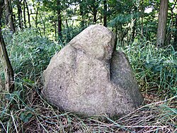
The menhir of Bucha , also called the tip stone , is a presumably Bronze Age menhir near Bucha , a district of Cavertitz in the district of northern Saxony .
location
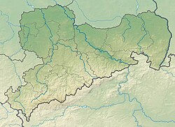
The menhir is located about 600 meters east of the hamlet Buchaer Zeuckritz on the road towards Schöna . There he stands on a slight hill.
description
The menhir is made of red granite . It is irregularly shaped, more rounded and tapers towards the top. It has a height of 87 cm, a width of 130 cm and a depth of 80 cm. It may once have been part of the stone enclosure of a Bronze Age burial mound and was only later moved to its current location.
literature
- Hans-Jürgen Beier : The megalithic, submegalithic and pseudomegalithic buildings and the menhirs between the Baltic Sea and the Thuringian Forest (= contributions to the prehistory and early history of Central Europe. Volume 1). Wilkau-Haßlau 1991, p. 71.
- Johannes Groht : Menhirs in Germany. State Office for Monument Preservation and Archeology Saxony-Anhalt / State Museum for Prehistory, Halle (Saale) 2013, ISBN 978-3-943904-18-5 , pp. 374, 381.
- Horst Kirchner : The menhirs in Central Europe and the menhir thought (= Academy of Sciences and Literature. Treatises of the humanities and social sciences class. Born 1955, No. 9). Wiesbaden 1955, p. 188.
- Waldtraut Schrickel : Western European elements in the Neolithic and the Early Bronze Age of Central Germany. Part 1. Catalog Leipzig 1957, pp. 69–70.
- Britta Schulze-Thulin : Large stone graves and menhirs. Saxony-Anhalt - Thuringia - Saxony. Mitteldeutscher Verlag, Halle (Saale) 2007, ISBN 978-3-89812-428-7 , p. 118.

