
Mine Howe

Minehowe is an archaeological site on the Orkney island of Mainland , Scotland .
location
Mine Howe is located in the southeast of Mainland's on the peninsula Tankerness , not far from the court of Breck and the grave mound Long Howe . Above this hill is a cemetery with a chapel dedicated to St. Ninian . The hill has a diameter of 95 m and is four meters high. It was created during the Ice Age (as a drumlin ).
Surname
The name Howe means "hill (ON haugr , locally Howie ) with the shaft". Local traditions also reported an installation in the hill.
- Minehowe
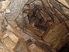
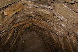
The vaulted ceiling

The stairs
The cistern

The found condition


Research history
The mound was excavated in April 1946 by Charles Tait and the local teacher, Alfie Hacus. A steep, narrow spiral staircase made of stone and a small underground chamber were discovered. The facility was interpreted as a Pictish dwelling. Some bones and teeth, round stones and a pile of shells were found. The shaft was closed and filled with barrels. The Inspector of Ancient Monuments was informed, but the excavation was never published.
In September 1999 the land owner, Douglas Paterson, carried out further digs. Since 2000 the "Orkney Archaeological Trust" has carried out systematic research with the support of Historic Scotland , Orkney Enterprise and the Orkney Island Council . In the Mine Howe environs project, the area around the hill is investigated.
structure
Seventeen stone steps lead into an underground chamber 1.3 m in diameter and 4 m high. It lies at a depth of about 7.5. The roof consists of a cantilever vault made of sandstone . The chamber was probably partially filled with water from the beginning and perhaps served as a cistern . Today it rarely contains water. A comparable but simpler structure is the well excavated in 1993 in the Broch von Breckness .
The hill is surrounded by a moat that is up to 8 m wide and 4.5 m deep. A wide entrance is on the west. The trench was cleaned and re-deepened several times. The backfilling of the trench shows that it was used from the early Iron Age to the middle of the first century AD (local late Iron Age). It contained numerous finds that prove a settlement, but above all handicraft activities. The remains of a metalworking workshop were found outside the trench. A young woman was buried under the floor of the workshop with rich grave goods . Another human skeleton was buried in a shallow pit without any gifts. A furnace for iron processing was also proven.
Dating
The facility dates from the Iron Age and has a parallel in the Knowe of Skea . Similar structures are also known from Caithness and the Shetland Islands .
literature
- Stephen Harrison (Ed.): Mine Howe. Fieldwork and excavation 2000-2005 (= The Friends of Orkney Archaeological Trust. Occasional Publication. 1). Friends of Orkney Archaeological Trust, Kirkwall 2005.
- Nick Card, Jane Downes: Mine Howe: The significance of space and place in the Iron age. In: Jane Downes, Anna Ritchie (eds.): Sea change. Orkney and Northern Europe in the later Iron Age AD 300-800. Pinkfoot, Balgavies 2003, ISBN 1-874012-38-5 , pp. 11-19.
Individual evidence
- ↑ A similar structure discovered on Orkney see http://www.orkneyjar.com/history/minehowe/minehowe3.htm has been forgotten, but shows that the Gurness Broch also had a staircase
Web links
Coordinates: 58 ° 56 '18.8 " N , 2 ° 51' 9.8" W.