
Mainland (Orkney)
| Mainland | |
|---|---|
 |
|
| Waters | North Sea |
| Archipelago | Orkney Islands |
| Geographical location | 58 ° 59 ′ N , 3 ° 6 ′ W |
 |
|
| length | 40 km |
| width | 26 km |
| surface | 523.25 km² |
| Highest elevation | Ward Hill 269 m |
| Residents | 17.162 (2011) 33 inhabitants / km² |
| main place | Kirkwall |
 |
|
Mainland , linguistically correct The Mainland Orkney , with 492 km² is the largest island of the Orkneys that belong to Scotland . The island is 40 km long and a maximum of 26 km wide, but at the Isthmus of Kirkwall it is only 2.5 km wide. In 2011 the population was 17,162. The highest point on the island is Ward Hill at 269 m.
The name is derived from Old Norse meginlant the big island. The name Hrossey (horse island) was in use during the Viking Age . The name Pomona , which appears occasionally today, was never an island name and is frowned upon by the locals. It appears in Dutch nautical charts of the 16th and 17th centuries and probably goes back to the fact that there was a pub of the name popular with Dutch fishermen in the western part of the island. This tradition remembers to this day the Pomona Inn , the pub the community Finstown .
In the 1950s, the pre-Christian sword of Groatsetter was found on Mainland .
Kirkwall is the largest town and administrative center of the Orkneys with 7500 inhabitants. Ferries run from here to the northern islands of the archipelago . Nearby is the airport with international and domestic flight connections to Aberdeen , Edinburgh , Glasgow , Inverness , the Shetlands and the northern neighboring islands.
From Orkney's second largest city with 2160 inhabitants, the port city of Stromness , ferries run to Scrabster and Hoy . Mainland has been connected to the southeastern islands of Burray and South Ronaldsay by the Churchill Barriers since World War II , from where there is another (short) ferry connection to John o 'Groats in Caithness (Scotland).
Mainland is topographically and geomorphologically divided into three parts:
- East Mainland (east of Kirkwall Isthmus)
- West Mainland (up to the narrow between Finstown and the Big Lochs)
- West Mainland (the remaining part, in the north)
Of the 21 administrative units (parishes) of the Orkney Islands, ten are on the main island of Mainland:
- Birsay and Harray
- Evie and Rendall
- Firth
- Spar
- Kirkwall and St Ola
- Orphir
- St Andrews and Deerness
- Sandwick
- Stenness
- Stromness
The islanders' economic base is mainly cattle breeding and fishing , especially lobster fishing . In the meantime, services and tourism have become more important.
In the east of East Mainland lies the Deerness peninsula . This is where Skaill is located, whose history goes back to the Stone Age . The name goes back to the foster father Thorfinn the Mighty, who was called Thorkel and is said to have managed a large estate here (called “Bu” in Norn). The recently demolished church from the 11th century is described by G. Low in 1774 as the most important of all parish churches, which was equipped with two towers (comparable to Egilsay ). One of the rare hogbacks comes from the graveyard of this church ; the Viking Age tombstone is now in the village church.
Attractions

- Ba'Games in Kirkwall and Stromness in late December
- St. Magnus Cathedral in Kirkwall
- Brough of Birsay and the Earl Palace
- Brough of Deerness
- Cuween Hill Cairn and Wideford Hill Cairn
- Farm museums in Corrigal and Kirbuster with Orcadian longhouses
- Grain and Rennibister basements
- Broch from Ayre
- Broch from Gurness
- Broch from Oxtro
- Horizontal watermill (Click Mill)
- Knowes o 'Trotty barrow cemetery
- Maes Howe (Stone Age passage tomb with Viking Age carvings)
- Orphir ruins of the round church of Orphir and Orkneyinga saga center (Viking settlement)
- Passage tombs ( Unstan ), type Stalled cairn and Quanterness
- Ring of Brodgar Ring of Bookan and Stones of Stenness ( stone circles ); nearby single menhirs ( Odin Stone ) and Barnhouse ( Neolithic village)
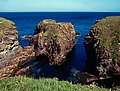
- Seal colonies west of Stromness
- Skara Brae (Neolithic settlement)
- Whiskey - Distilleries Highland Park and Scapa

The Magnus Cathedral in Kirkwall
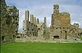
Earl's Palace in Birsay
The Brough of Deerness

Seals on the south coast of Mainland. The island in the background is Hoy


Also noteworthy are the sights on the islands connected by the Churchill Barriers , such as the Italian Chapel on Lambs Holm and the Stalled Cairn Isbister Cairn (Tomb of the Eagle) and the Ancient cooking place Liddle Burnt Mound on South Ronaldsay , which the former farmer owned Take care of Ronnie Simison and his daughter (including a small private museum).
Individual evidence
Web links
- Mainland location orkneyjar.com - Private homepage about the Orkney Islands (English)
Auskerry | Burray | Calf of Eday | Cava | Copinsay | Damsay | Eday | Egilsay | Eynhallow | Fara | Faray | Flotta | Gairsay | Graemsay | Holm of Grimbister | Holm of Huip | Holm of Papa | Hoy | Lamb Holm | Linga spar | Mainland | Muckle Skerry | North Ronaldsay | Papa Stronsay | Papa Westray | Rousay | Rysa Little | Sanday | Shapinsay | South Ronaldsay | Stronsay | Sule Skerry | Column stack | Switha | Swona | Westray | Wyre