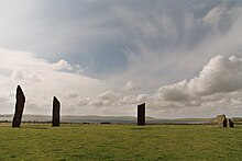
Stones of Stenness
The Stones of Stenness are a Neolithic henge monument (class I henge) located on the Mainland Island of Orkney . They have been under state protection since 1906 and have been part of the Heart of Neolithic Orkney UNESCO World Heritage since 1999 ; their preservation and reconstruction are thus promoted by the World Heritage Committee .
location
The Stones of Stenness are located between the Loch of Stenness and the Loch of Harray near the Neolithic settlement of Barnhouse within sight of the Passage Tomb of Maes Howe, a mile south-east of the Ring of Brodgar .
Arrangement and structure
The erection of the stones was confirmed by radiocarbon dating to the year 3100 BC. Dated BC, Stenness is one of the earliest stone circles in Britain. So it was created at the same time as "Maes Howe". Of the 12 stones in the inner circle, four are still standing today. The henge lacks the surrounding moat and wall. Excavations have shown that the trench was 4 meters wide and 2.3 meters deep. The four remaining stones belong to an oval 30 meters in diameter.
In the center there is a large fireplace that is still visible today. There is still a paved path, several stones set up, apparently another fireplace and posts of a three-stone "dolmen" - the fireplace apparently fulfilled a central function. Ceramics and animal bones found during excavations show that the Neolithic builders cooked and ate regularly on the site.
The stones are about five meters high, the highest over 5.7 meters, and a maximum of 30 cm thick. They are arranged in an ellipse with a diameter of 31.7 meters. They stand on a level that was surrounded by an almost closed 6 meter wide and 2.3 meter deep trench carved into the sandstone of the subsoil. Around the ditch, the ends of which are round in the passage area, there is a remains of earth wall with a diameter of 44 m and an access on the north side. The entrance points towards "Barnhouse". In 1973, during excavations, a box-shaped arrangement of stones was found in the middle of the henge, which had notches for stones or wood. Burned bones , charcoal and pottery were found in it. Bones of dogs, cattle and sheep, as well as a human finger bone were found in the trench. The ceramics ( Grooved Ware ) indicate a connection between the stone circle and the plants of Maes Howe and Skara Brae .
It is assumed that the ensemble of the stone circle includes other stones in the vicinity. These are the Watchstone (5.5 m high), the Barnhouse Stone and the destroyed Odin Stone .
Purpose of the stone circle
Nothing more can be said about the purpose of the stone circle today. A possible purpose can only be recognized at the nearby Watchstone : At the winter solstice, the sun sets exactly between the “Hoy Mountains” when viewed from the “Watchstone”.
construction
It is estimated that it would have taken a single person 5000 days to erect the stones inside and dig the trench. By comparison, the Ring of Brodgar only took up about half of this working time.
It is still unclear how the stones were transported. The quarry for the stones is in all likelihood Vestra Fiold, a hill north of Skara Brae.
There are mainly two theories about this:
- The stones were rolled on logs, which were repeatedly placed in front of the stone. In contrast to today, the Orkneys were still a bit wooded.
- The stones could have been shipped across the sea.
Destruction and reconstruction
In 1814 the farmer Captain MacKay tried to destroy the stones because visitors to the stone circle kept trampling his field. He destroyed the "Odin Stone" located further away, overturned one of the stones inside the arrangement and damaged others. The section with the hole of the "Odin Stone" was apparently misused as a joint for a horse mill. But this part was also destroyed when the horse mill was demolished. In 1906 the fallen stone was raised again. A smaller stone was found, which was also raised. However, there is speculation about whether the smaller stone actually belongs to the arrangement.
In 1907 the dolmen , which Sir Walter Scott had called the altar, was reconstructed . It consists of two small erect stones and a stone slab. It is speculated whether it is actually a dolmen or originally a cove with three upright stone slabs. In 1972 this reconstruction was destroyed by a party on the premises and the flagstone fell off.
literature
- UNESCO report on the World Heritage "The Heart of Neolithic Orkney" (English, 181 KB, last accessed on January 2, 2008; PDF file)
Individual evidence
- ^ Rodney Castleden: The Stonehenge People. An exploration of life in Neolithic Britain, 4700-2000 BC. Routledge & Kegan Paul, London et al. 1987, ISBN 0-7102-0968-1 , p. 146.
Web links
- Orkneyjar.com (English)
- Undiscoveredscotland.co.uk (English)
- Stonepages.com (English)
- Megalithic.co.uk (English)
- Maeshowe.co.uk (English)
Coordinates: 58 ° 59 ′ 40 ″ N , 3 ° 12 ′ 25 ″ W.

