
Lamb Holm
| Lamb Holm | |
|---|---|
 |
|
| Waters | North Sea |
| Archipelago | Orkney |
| Geographical location | 58 ° 53 '17 " N , 2 ° 53' 31" W |
 |
|
| length | 1.1 km |
| width | 560 m |
| surface | 40 ha |
| Residents | uninhabited |
Lamb Holm , also Lambholm , is an island in the Orkney Islands . It is just south of Mainland , the main island of the Orkneys. The island lies off the south-east coast of Mainland and is separated from it by a strait around 500 m wide . The neighboring island of Glimps Holm is 600 m to the southwest . With a length of 1.1 km, Lamb Holm is a maximum of 560 m wide. It covers an area of 0.4 km 2 . While there were seven residents in 1871 and eight in 1881, Lamb Holm is uninhabited today.
Buildings
The strait between Lamb Holm and Mainland represents a possible access route into the Scapa Flow , in which the British Navy maintained an important base. After both the First and the Second World War had penetrated German warships in Scapa Flow, developed in the 1940s with the Churchill Barriers , a system of dams between the islands as effective submarine barrier. In the course of this, the strait between Lamb Holm and Mainland, through which the submarine U 47 penetrated in October 1939 and sank the warship HMS Royal Oak, was closed. To the south, the dam system continues over Glims Holm and Burray to South Ronaldsay . Today the A961 connects the islands with Kirkwall via these dams .

Route from U 47 through the strait
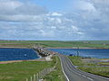
Dam between Lamb Holm and Mainland


During the Second World War, Italian prisoners of war were interned at Lamb Holm. Between 1942 and 1944 they created the Italian Chapel, a church that is now listed in the Scottish monuments lists in the highest category A.

Interior of the church

Italian war memorial


Individual evidence
- ↑ a b Lamb Holm. In: David Munro, Bruce Gittings: Scotland. An Encyclopedia of Places & Landscapes. Collins et al., Glasgow 2006, ISBN 0-00-472466-6 .
- ↑ entry. In: Gazetteer for Scotland. 2011.
- ↑ Lambholm. In: Francis H. Groome: Ordnance Gazetteer of Scotland: A Survey of Scottish Topography, Statistical, Biographical and Historical. Volume 4: (Har - Lib). Thomas C. Jack, Grange Publishing Works, Edinburgh et al. 1885, p. 452 .
- ↑ Statistical data ( memento of the original dated December 23, 2014 in the Internet Archive ) Info: The archive link was inserted automatically and has not yet been checked. Please check the original and archive link according to the instructions and then remove this notice. (PDF; 1.7 MB)
- ^ Churchill Barriers. In: David Munro, Bruce Gittings: Scotland. An Encyclopedia of Places & Landscapes. Collins et al., Glasgow 2006, ISBN 0-00-472466-6 .
- ↑ Listed Building - Entry . In: Historic Scotland .
Web links
Auskerry | Burray | Calf of Eday | Cava | Copinsay | Damsay | Eday | Egilsay | Eynhallow | Fara | Faray | Flotta | Gairsay | Graemsay | Holm of Grimbister | Holm of Huip | Holm of Papa | Hoy | Lamb Holm | Linga spar | Mainland | Muckle Skerry | North Ronaldsay | Papa Stronsay | Papa Westray | Rousay | Rysa Little | Sanday | Shapinsay | South Ronaldsay | Stronsay | Sule Skerry | Column stack | Switha | Swona | Westray | Wyre