
Hoy (Orkney)
| Hoy | |
|---|---|
 |
|
| Waters | North Sea |
| Archipelago | Orkney |
| Geographical location | 58 ° 51 ′ N , 3 ° 18 ′ W |
 |
|
| length | 20 km |
| width | 9 km |
| surface | 143.18 km² |
| Highest elevation | Ward Hill 479 m |
| Residents | 419 (2011) 2.9 inhabitants / km² |
| main place | Lyness |
 |
|
Hoy is with an expansion of about 20 × 9 kilometers and a size of 143.18 square kilometers, the second largest island ( "high island" of altnordisch Ha-ey) Orkney and is, by this broad by the three kilometers Hoy sound isolated , south of the main island Mainland .
The highest point of Hoys and the Orkney is Ward Hill with 479 m. In 1881 the island still had 1,380 inhabitants, today only 419 people live here from agriculture, fishing and some tourism.
Administratively, the island is divided into the municipalities of Hoy & Graemsay and Walls .
Attractions

The main attractions are the Old Man of Hoy , a 137 m high rock needle from Rotliegend , located in the northwest on the cliff , and a little north of it the steep cliffs of St. Johns Head , with more than 400 m height the second highest cliff in the British Isles . At the eastern end of the south coast is Cape Cantick Head , where a 22 m high lighthouse has been in operation since 1858 . On the north coast are the remains of the Broch of Braebister.
The interior of the approximately 2.35 meter long rock grave Dwarfie Stane was carved out of a 8.5 meter long rock fall. It is the northernmost occurrence of this Neolithic grave type in Europe. Dwarfie Stane is about 50.0 meters off the road, about halfway between Moaness Pier and the hamlet of Rackwick on the northwest coast.
On the Green Hill of Hesti Geo, not far from the Candle of Snelsetter and two Gloups (sea cavities ), there is a large and unusually shaped brochure. The approximately 4.0 m high hill contains a considerable brochure, a quarter of which was lost in the sea.
The Lyness Naval Base, for decades the base of the British Royal Navy , now serves as a museum under the name Scapa Flow Visitor Center to illustrate the military-historical significance of Scapa Flow .
South Walls


In the extreme south, Hoy extends around the South Walls peninsula . The original island can be reached by means of a recently built dam. The Martello towers Hackness North & South are located around Longhope Bay, which lies between Hoy and South Walls . On the coast there are numerous relics of the former fortifications of Scapa Flow . On the east coast is the anchorage Osmondwall (today Kirk Hope) the Asmundavagr of the Orkneyinga saga from the Viking Age . There, in the year 955 AD, the Jarl Sigurd the Stout was allegedly given the choice by Olav I. Tryggvason : baptism or beheading. Melsetter House is the most important evidence of the work of the British architectural theorist William Lethaby . Parts of the interior furnishings that go back to William Morris have been preserved to this day.
Otherwise, the second largest island in Orkney is a winter home for barnacle geese and a paradise for hikers and nature lovers. Almost the entire Hoy portion of the municipality of Hoy & Graemsay from the north to the center of the island is a bird sanctuary of the Royal Society for Protection of Birds (RSPB).
traffic
There are ferry connections from Moaness Pier to Stromness (pedestrians and bicycles) and from Lyness to Houton (roll-on-roll-off); both to Mainland . Unlike northern Orkney, Hoy does not have an airfield.
Trivia
- Hoy was the filming location for the music clip of the music piece Here Comes the Rain Again by the British pop duo Eurythmics .
gallery

Hoy cliff coast

View of Rackwick Bay.
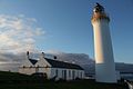
Cantick Head, lighthouse with lighthouse keeper's house

Melsetter House seen from the rear

Longhope Village, South Walls

15 cm quick-loading cannon L / 45 from SMS Bremse in the Scapa Flow Visitor Center

Seals in front of the silhouette of Hoy


Web links
- Location of the island of Hoy
- Melsetter House on Undiscovered Scotland , online guide , accessed April 10, 2010
- Lighthouse locations in Scotland on Northern Lighthouse Board , accessed April 10, 2010
Individual evidence
- ↑ 2011 census data
- ^ Cantick Head on GeoNames , accessed April 10, 2010
- ^ Cantick Head Lighthouse on Northern Lighthouse Board , accessed April 10, 2010
Auskerry | Burray | Calf of Eday | Cava | Copinsay | Damsay | Eday | Egilsay | Eynhallow | Fara | Faray | Flotta | Gairsay | Graemsay | Holm of Grimbister | Holm of Huip | Holm of Papa | Hoy | Lamb Holm | Linga spar | Mainland | Muckle Skerry | North Ronaldsay | Papa Stronsay | Papa Westray | Rousay | Rysa Little | Sanday | Shapinsay | South Ronaldsay | Stronsay | Sule Skerry | Column stack | Switha | Swona | Westray | Wyre