
A961 road
| A961 road in the UK | |
| map | |
 |
|
| Basic data | |
| Operator: | |
| Start of the street: |
Kirkwall ( 58 ° 59 ′ N , 2 ° 57 ′ W ) |
| End of street: |
Burwick ( 58 ° 44 ′ N , 2 ° 58 ′ W ) |
| Overall length: | 33 km (20.5 mi ) |
 |
|
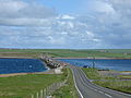
| The A961 on South Ronaldsay | |
|
Course of the road
|
|
The A961 road is an A-road in the Scottish Orkney Islands . In total, it leads over five islands with Mainland , Lamb Holm , Glims Holm , Burray and South Ronaldsay , which are connected by dams.
course
The A961 branches off the A960 in the south of the island's capital, Kirkwall . It runs in a southerly direction near the east coast from Scapa Bay to Holm on the south coast. The A961 leads over a dam, the northernmost of the Churchill Barriers built during the Second World War , to the uninhabited island of Lamb Holm. Passing the listed emergency church Italian Chapel in the west, the road leaves Lamb Holm on the southwest coast and reaches the also uninhabited island of Glims Holm via the second dam of the Churchill Barriers.
The A961 runs south over the third Churchill Barrier to Burray. Going over a dam on the north coast of the island, it cuts the head of Echna Loch from the sea and reaches Burray Village on the south coast. The fourth of the Churchill Barriers will eventually bring the road to the island of South Ronaldsay. In a south-westerly direction connecting the island's capital St. Margaret's Hope , the A961 bends south and ends after a total length of 33 km at the ferry terminal to John o 'Groats near the settlement of Burwick .

The A961 south of Kirkwall
Churchill Barrier 1 between Mainland and Lamb Holm

Dam at the head of Echna Loch


