
St. Margaret's Hope
| St. Margaret's Hope | |||
|---|---|---|---|
| Coordinates | 58 ° 50 ′ N , 2 ° 58 ′ W | ||
|
|||
| Residents | 550 | ||
| administration | |||
| Post town | ORKNEY | ||
| ZIP code section | KW17 | ||
| prefix | 01856 | ||
| Part of the country | Scotland | ||
| Council area | Orkney | ||
| British Parliament | Orkney and Shetland | ||
| Scottish Parliament | Orkney | ||

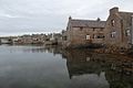
St. Margaret's Hope (known locally as The Hope , pronounced "Hup") is a village on the Orkney island of South Ronaldsay in northern Scotland . It has a population of about 550 and is the third largest settlement in the Orkney after Kirkwall and Stromness .
The site is located on Water Sound, at the inner tip of a sheltered bay on the north coast of the island of South Ronaldsay, which is connected to the main island of Mainland via the Churchill Barriers ( A961 ) , and is a popular destination for the people of Kirkwall. Pentland Ferries operate a ferry service to Gills Bay on the Scottish mainland.
"The Hope" is the most important village on the island and is named either after Queen Margaret , the "Maid of Norway", who died there in 1290, or after Queen Margaret of Scotland , the wife of Malcolm III. The latter explanation comes from Victorian Ordnance Survey maps, which trace the name back to an early Christian St. Margaret's chapel. The village has a primary school, a museum and a number of shops and restaurants. It is known for its annual plowing competition , a local tradition on the Wright Sands.
Traces of an Iron Age brochure lie in a field above the village, to the south is the Clouduhall Stone .
St. Margaret's Hope
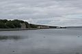
View of St. Margaret's Hope ferry terminal

"Waterside"


Web links
- St. Margaret's Hope at Undiscovered Scotland (English)
- The plowing competition (BBC video, English)