Minnesota State Route 74

|
|
|---|---|
| Basic data | |
| Overall length: | 30 mi / 48 km |
| Opening: | 1933 |
| Starting point: |
|
| End point: |
|
| Counties: |
Fillmore County Olmsted County Winona County Wabasha County |
| Important cities: | St. Charles , Elba |
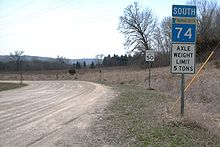
Minnesota State Route 74 is a 30 miles long state route in the southwest of the US state of Minnesota , which leads from Chatfield to the Mississippi River . It is the only road in the Minnesota highway system that contains a dirt section. The route runs from north to south.
The road begins at the intersection of US Highway 52 and State Route 30 in Chatfield . It heads north through the parishes of Troy and Saratoga to the intersection with Interstate 90 , which is south of St. Charles . In St. Charles street is to merge with the 14 US Highway the Whitewater Avenue called Main Street. On Highway 14, Route 30 heads west for a little less than a mile and then turns north where the route passes through Whitewater State Park and the small town of Elba . At the north end of this section, 7 miles (11 km) of the road is a dirt stretch of gravel . The road ends on US Highway 61 in Weaver on the Mississippi River .
The highway used to start further south of Chatfield, so the mileage starts at 20 today. Part of the route follows an old road that was one of the first public roads in Minnesota. On April 18 and 19, the flooding of the Whitewater River, Minnesota , destroyed several bridges and washed out the road. In 2008 all repairs were completed.

