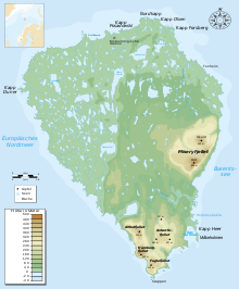
Miseryfjellet
| Miseryfjellet | ||
|---|---|---|
| height | 536 m | |
| location | Bear Island , Svalbard , Norway | |
| Coordinates | 74 ° 24 '50 " N , 19 ° 11' 15" E | |
|
|
||
| Age of the rock | Triad | |
| particularities | highest mountain on Bear Island | |
The Miseryfjellet is the highest mountain in the Bear Island ( Bjørnøya ). It is located in the east of the island. Its three peaks, collectively also called the Tre Kronor , are named after the Norns of Norse mythology Urd , Verdande and Skuld . In the Urd it reaches its maximum height of 536 meters. Some sources even give 563 m. The mountain consists of Triassic rock and thus belongs to the youngest geological unit on the island.
Web links
- Miseryfjellet . In: The Place Names of Svalbard (first edition 1942). Norsk Polarinstitutt , Oslo 2001, ISBN 82-90307-82-9 (English, Norwegian).
Individual evidence
- ↑ Tre Kronor . In: The Place Names of Svalbard (first edition 1942). Norsk Polarinstitutt , Oslo 2001, ISBN 82-90307-82-9 (English, Norwegian).
- ↑ Nicholas C. Matalas, Bernardo F. Grossling: Habitat and environment of islands: primary and supplemental island sets (PDF; 7.98 MB), US Geological Survey professional Paper 1590, Reston, Virginia 2002, ISBN 0-607-99508- 4 , accompanying CD-ROM (PDF; 27.57 MB), p. 152.
- ↑ a b David Worsley, Torleiv Agdestein, John G. Gjelberg, Knut Kirkemo, Atle Mørk, Inger Nilsson, Snorre Olaussen, Ron J. Steel, Lars Stemmerik: The geological evolution of Bjørnøya, Arctic Norway: implications for the Barents Shelf (PDF ; 6.36 MB). In: Norsk Geologisk Tidsskrift , 81, 2001, pp. 195-234.
- ^ Hannu Hyvärinen: Late-Quaternary Sediment Cores from Lakes on Bjornoya . In: Geografiska Annaler. Series A, Physical Geography 50, No. 4, 1968, pp. 235-245.


