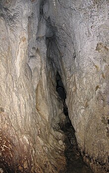
Moon milk hole
The Mondmilchloch is a karst cave in the Pilatus massif ( Emmental Alps ) in Switzerland . It is the type locality of the so-called moon milk .
Location and access
The moon milk hole is on the south side of the Widderfeld at an altitude of 1710 m above sea level. M. The entrance to the cave is only recognized when you stand in front of it. The stream that rises from the cave can serve as a guide.
From the buildings of Alp Birchboden ( 1610 m above sea level ), a path marked with orange dots leads first level, then slightly uphill over pastureland, scree slopes and through strips of forest to the entrance of the cave .
Cave description
The cave has a length of 108 m and a total gradient of around 20 m. The hall-like vestibule and the transition area lead to the column-shaped part of the cave (approx. 40 m). At 52 m there is a jammed rock block. From 57 to 62 m there is a low cross-section that only allows you to progress on all fours. You get to the first waterfall with a height of 3.3 m. This is followed by a slightly rising section with smaller steps until a side passage opens to the right at approx. 80 m, from which water flows in. Now you get to the narrowest passage of approx. 20 cm («mousetrap»). At 100 m there is the second waterfall 2.2 m high. Shortly afterwards the water comes in from the ceiling and with it the end of the accessible cave.
Historical
The moon milk hole was first mentioned in 1555. The moon milk was introduced by Conrad Gesner under the name "Lac Lunae" in the official drug treasure. As a result, the agent (a calcite precipitate) became widely known and was recommended by doctors in the 19th century.
etymology
"Moon milk hole" means cave in which moon milk (lat. Lac Lunae) is available in large quantities.
geology
The moon milk hole is created along a tectonic break in the lower Schrattenkalk and was created by the dissolution of carbonate rock by carbonated water. On the ridge of the Widderfeld, funnel dolines can be seen in the thin, tertiary quartz sandstone ( Hohgantsandstein ) . The seeping water finds its way into the moon milk hole via fissures in the Schrattenkalk below.
When the water flows or drips down the cave walls, chemically pure calcium carbonate can precipitate. A whitish, porous mineral aggregate develops, the moon milk .
literature
- Hans Fischer: Cave Mondmilchloch, a monograph , Lucerne 1987
- Moritz Anton Kappeler : Pilati Montis Historia , Basel 1767, (German translation: Naturgeschichte des Pilatusberg), pp. 219–226 and 231–233, Verlag Haag, Lucerne 1960
Coordinates: 46 ° 58 ′ 0.4 " N , 8 ° 13 ′ 10" E ; CH1903: six hundred and fifty-nine thousand four hundred twenty-one / 202041
