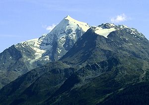
Mont Pourri
| Mont Pourri | ||
|---|---|---|
|
Mont Pourri |
||
| height | 3779 m | |
| location | Savoy department , France | |
| Mountains | Vanoise massif , Graian Alps | |
| Coordinates | 45 ° 32 ′ 0 ″ N , 6 ° 52 ′ 0 ″ E | |
|
|
||
| First ascent | October 4, 1861 by Michel Croz single- handedly | |
| particularities | second highest mountain in the Vanoise massif | |
At 3779 m, Mont Pourri is the second highest mountain in the Vanoise massif after the Grande Casse , a subgroup of the Graian Alps in the French department of Savoy .
After William Mathews , who in 1860 had already succeeded in the first ascent of the Grande Casse together with Michel Croz , then failed on Mont Pourri, he commissioned Croz to explore the best ascent route. Michel Croz made the first ascent on October 4, 1861.
The name of the mountain literally means " corrupt mountain " in French . However, since the region belongs to the (traditional) Arpitan (Franco-Provencal) language area, this does not necessarily correspond to the original meaning.
The Refuge du Mont Pourri is the starting point of the normal route to Mont Pourri.

