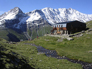
Refuge du Mont Pourri
| Refuge du Mont Pourri CAF hut |
||
|---|---|---|
| location | Department of Savoie ; Auvergne-Rhône-Alpes , France | |
| Mountain range | Vanoise massif | |
| Geographical location: | 45 ° 31 '40.8 " N , 6 ° 49' 37.2" E | |
| Altitude | 2373 m | |
|
|
||
| owner | Club Alpin Français Chambery section | |
| Construction type | hut | |
| Usual opening times | Mid-March to mid-May, mid-June to mid-September | |
| accommodation | 55 beds, 0 camps | |
| Winter room | 50 bearings | |
The Refuge du Mont Pourri is a refuge located in the Savoie department in the Auvergne-Rhône-Alpes region . The refuge, located at an altitude of 2373 m, belongs to the Chambery section of the Club Alpin Français .
history
Already at the beginning of the 20th century there was a hut near the Grand Col. However, there are no remains of this building. The current building was erected in 1974 and replaced the Refuge Regaud , about 20 minutes away , which was converted into an exhibition room on mountaineering on Mont Pourri .
description
The refuge is open from mid-June to mid-September, during which time it offers 55 hikers overnight accommodation. Outside of this time, a total of 50 beds are available.
Approach
The hut can be reached in the following ways:
- from the hamlet of Beaupraz (altitude 1550 m), part of the municipality of Peisey-Nancroix . The path initially leads in the direction of the chapel and ascends in an easterly direction to the refuge. Allow about 2h30 for the ascent.
- From the refuge de Rosuel (altitude 1557 m), which is not far from the hamlet of Beaupraz, first take the long-distance hiking trail GR 5 , then turn left towards Plan de la Plagne. Allow about 2h45 for the walk. This path crosses a number of small streams that carry a lot of water, especially at the beginning of the hiking season. The administration of the Vanoise National Park ensures that the bridges can be used by mid-June at the latest. Alternatively, there is a path from Rosuel via the Via ferrata des Bettières (especially the third section of the via ferrata is difficult).
- From Arcs 1800 you can take the cable car to the second station, Transarc. From there you first take the drivable path towards Col de la Chal . For the easy way you should plan around 1h20. From the Col de la Chal you can plan a detour to the Lac des Moutons ;
Tour possibilities
The hut is a stage destination on the following circular hiking trails:
- Le Tour du Mont Pourri (3 days);
- Le Tour de la Pointe du Vallaisonnay (4 days).
The Grand Col (the path first leads to Lake Lac des Moutons ) and the Glacier du Geay glacier (via Refuge Regaud) can be reached from the hut .
Alpine climbs
The hut is the starting point for tours on Mont Pourri , which, at 3779 m, is the second highest peak in the Savoie department. There are also tours on the Mont Turia , the Aiguille du Saint-Esprit, the Dôme de la Ding and the Dôme des Platières .
The Brèche Poccard , which can be reached in 1h30, offers climbers several ascents in difficulty 5c to 6b. The Aiguille du Saint-Esprit , which is close to the hut, also has a fully developed climbing route with a difficulty of 5c.
Web links
- Refuge du Mont Pourri. CAF(French).
- Refuge du Mont Pourri. In: cafchambery.com. (French).
- Refuge du Mont Pourri. In: refuges.info. (French).
- Refuge du Mont Pourri. In: camptocamp.org. (French).
- Refuge du Mont Pourri. In: skitour.fr. (French).

