Mont Valier
| Mont Valier | ||
|---|---|---|
|
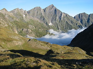
Mont Valier, view from the Port d'Aula |
||
| height | 2838 m | |
| location | France | |
| Mountains | Pyrenees | |
| Coordinates | 42 ° 47 '52 " N , 1 ° 5' 8" E | |
|
|
||
| First ascent | supposedly in the 5th century | |
The Mont Valier is a max. 2838 m high mountain in the south of the Ariège department in the central Pyrenees in southern France . It is named after the half-legendary Bishop Valerius, who is said to have climbed the mountain in the 5th century.
location
The Mont Valier is entirely in the territory of the French commune of Seix ; nearest city is Saint-Girons .
Rivers
The rivers Ger and Salat have their source on the flanks of the mountain ; both are southern tributaries of the Garonne .
Ascent
The easiest but still challenging route leads from the south to the summit.
history
During the Second World War, an escape route led to Spain near Mont Valier.
Web links
Commons : Mont Valier - Collection of Images, Videos and Audio Files
- Mont Valier - map + brief information (peakbagger, English)

