Monte Capanne
| Monte Capanne | ||
|---|---|---|
|
View from the sea to Monte Capanne |
||
| height | 1019 m slm | |
| location | Elba Island , Italy | |
| Coordinates | 42 ° 46 '16 " N , 10 ° 10' 2" E | |
|
|
||
| particularities | highest mountain on the island of Elba | |
|
Ascent to Monte Capanne |
||

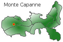
Of the western part of the island Elba forming Capanne is 1019 m slm the highest point on the island. The mountain is made of granodiorite . On the north side of the Capanne massive , chestnut forests and scrub forest, the so-called macchia, grow . The south side, however, is quite bare.
There are numerous springs in the area . Fonte Napoleone is on the road from Poggio to Marciana . Here you can fill up mineral water directly at the source for free .
There are six hiking trails that lead from Marciana, Poggio, Valle Nevera , Chiessi and Pomonte to the top of Monte Capanne. From Marciana Alta you can take the cable car to the summit in just under 20 minutes , standing in lattice gondolas. From there you can have a panoramic view over Elba and the sea. On a clear day the view extends over the six smaller Tuscan islands , to the coast of the mainland and to Corsica .


