Monte Gordo
| Monte Gordo | |||||
|---|---|---|---|---|---|
|
|||||
| Basic data | |||||
| Region : | Algarve | ||||
| Sub-region : | Algarve | ||||
| District : | Faro | ||||
| Concelho : | Vila Real de Santo Antonio | ||||
| Coordinates : | 37 ° 11 ′ N , 7 ° 27 ′ W | ||||
| Residents: | 3308 (as of June 30, 2011) | ||||
| Surface: | 4.22 km² (as of January 1, 2010) | ||||
| Population density : | 784 inhabitants per km² | ||||
| politics | |||||
| Address of the municipal administration: | Junta de Freguesia de Monte Gordo Estrada Municipal 8900-402 Monte Gordo |
||||
| Website: | www.jfmontegordo.pt | ||||
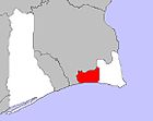
Monte Gordo is a parish in the Vila Real de Santo António district of the Faro district in Portugal .
The place has an area of 4.2 km² and 3308 inhabitants (as of June 30, 2011) and was elevated to Vila on June 12, 2001 .
traffic
The place is connected via the Estrada Nacional N125 to the Autoestrada A22 , which runs through the Algarve in an east-west direction . Nearby is the Praia Verda small airport for sport and private planes.
beaches
- The beach Praia de Adão e Eva borders on the Praia de Monte Gordo in the west and Praia do Cabeço - Retur in the east. It is surrounded by a forest of pine and maritime pines, one of the few chameleon species in Portugal.
Sports
The GD Beira Mar was a sports club in Monte Gordo. It was founded on August 2, 1950 and stopped playing in 2011 with the withdrawal from the III Divisão.
Individual evidence
- ↑ www.ine.pt - indicator resident population by place of residence and sex; Decennial in the database of the Instituto Nacional de Estatística
- ↑ Overview of code assignments from Freguesias on epp.eurostat.ec.europa.eu
Web links
Commons : Monte Gordo - Collection of images, videos and audio files
- Map of the Freguesia Monte Gordo at the Instituto Geográfico do Exército
- Description of Monte Gordo on algarve-reisen.com, accessed on June 19, 2010


