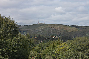
Monte Pedroso
| Monte Pedroso | ||
|---|---|---|
| height | 461 m | |
| location | A Coruña , Galicia , Spain | |
| Coordinates | 42 ° 55 '0 " N , 8 ° 34' 0" W | |
|
|
||
| rock | granite | |
|
Petroglyphs from Monte Pedroso |
||
The Monte Pedroso is a 461 m high of granite mountain in the northern Spanish city of Santiago de Compostela in the parish of Santa Maria Figueiras.
It is only 3 km from the center of the capital of the Autonomous Community of Galicia . It can be reached through orchards and the Calzada del Carmen, a half-hour walk from the cathedral . The mountain is on the right side of the Sarela River , over which a preserved medieval bridge runs. From its summit (461 m) there is a good view of Santiago de Compostela and other mountains such as Fontecova . At the top there are antennas and converters for radio and television. The conifer forest with chestnuts, eucalyptus and oaks was badly damaged by a fire in the summer of 2006. Another major forest fire occurred in June 2011.
In the vicinity of the summit, chalk-marked spiral petroglyphs attest to the presence of man since the Stone and Bronze Ages.
Web links
- Summit plateau of Monte Pedroso near Panoramio
Individual evidence
- ↑ Monte Pedroso on turgalicia.es
- ↑ Parque de Granxa do Xesto ( Memento of the original from April 23, 2011 in the Internet Archive ) Info: The archive link has been inserted automatically and has not yet been checked. Please check the original and archive link according to the instructions and then remove this notice. on cityoos
- ↑ Monte Pedroso on waymarking.com
- ↑ Controlado el incendio del monte Pedroso, en Santiago , La Voz de Galicia , June 24, 2011, accessed July 13, 2011
- ↑ http://www.artifexbalear.org/petroglifos.htm


