Morrón de Mariné
| Morrón de Mariné | ||
|---|---|---|
|
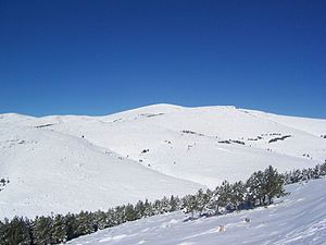
The snow-capped highest peaks of the Sierra de Gádor with the Morrón de Mariné |
||
| height | 2244 msnm | |
| location | Community Dalías , province of Almería , Community of Andalusia , Spain | |
| Mountains | Sierra de Gádor , Betic Cordillera | |
| Notch height | 1320 m ↓ On the A 348 west of Laujar de Andarax | |
| Coordinates | 36 ° 54 '12 " N , 2 ° 49' 39" W | |
|
|
||
The Morrón de Mariné (also: Morrón de la Lagunilla ) is the highest peak of the Sierra de Gádor , a part of the Betic Cordillera , which overlooks the coastal plain of the Spanish province of Almería, also known as Mar de Plástico because of its many greenhouses . In contrast to the slightly lower, neighboring summit Nuevo Mundo with its antenna system, which can also be reached by vehicle via a slope, there are neither slopes nor marked hiking trails on the little-visited Morrón de Mariné.
Maps & literature
- Centro Nacional de Información Geográfica (ed.): MTN50 1: 50.000, sheet 1044: Alhama de Almería
- José Martínez Hernández: Las 100 cumbres más prominentes de la península Ibérica. Ediciones Desnivel, Madrid, ISBN 978-84-9829-203-9
photos
The antenna system at the summit of Nuevo Mundo , the Mar de Plástico and the Mediterranean from the Morrón de Mariné
Individual evidence
- ↑ Morrón de la Lagunilla on OpenStreetMap, accessed on June 4, 2020
- ↑ https://www.peakbagger.com/KeyCol.aspx?pid=44976
- ↑ So z. B. in the Spanish Wikipedia. On the official map (see "Maps & Literature!), However, there is the preferred name Morrón de Mariné
- ↑ https://www.cnig.es/detalleArticulo?articulo=9788441600195-1044-Alhama-de-Almer%C3%ADa


