Motuopao Island
| Motuopao Island | ||
|---|---|---|
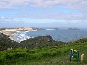
| Taupiri Island (left), Cape Maria van Diemen (center) and Motuapao Island (right) | ||
| Waters | Tasman Sea | |
| Geographical location | 34 ° 28 ′ 13 ″ S , 172 ° 38 ′ 18 ″ E | |
|
|
||
| length | 110 m | |
| width | 600 m | |
| Highest elevation | 110 m | |
| Residents | uninhabited | |
| View from Cape Reinga over Te Werahi Beach to Cape Maria von Diemen, Motuopao Island is on the far right | ||
Motuopao Iceland is an island off the aupouri peninsula in the region Northland on the North Island of New Zealand . It is located about 300 meters northwest of the westernmost point of the mainland of the North Island, Cape Maria van Diemen . The island is about 1100 meters long and 600 meters wide. The island reaches its highest point in the north at 110 meters, which was the location of the Motuopo Lighthouse .
Until 1939 there was a now abandoned lighthouse on Motuopao Island, which was difficult to reach, especially in heavy seas. In 1941, the new lighthouse at Cape Reinga with many parts of the old lighthouse was completed and started operating in May of the same year.
Individual evidence
- Topographic map AT24 , LINZ


