
Cape Reinga
|
Cape Reinga Māori : Te Rerenga Wairua |
||
 Cape Reinga |
||
| Geographical location | ||
|
||
| Coordinates | 34 ° 25 ′ S , 172 ° 41 ′ E | |
| location | Far North District , Northland Region, North Island | |
| Waters | Tasman Sea | |
| Waters 2 | Pacific Ocean | |
| length | 1 100 m | |
| width | 1 500 m | |
| surface | 83 ha | |
| height | 157 m | |
| lighthouse | Cape Reinga Lighthouse | |
| particularities | northwesternmost point of the North Island | |
.jpg) Lighthouse with distance indicator |
||

Cape Reinga , in the language of the Māori Te Wairua Rerenga called, is a chapter in the Far North District of the Region Northland on the North Island of New Zealand .
geography
Cape Reinga is located on the northwest tip of the Aupōuri Peninsula , 95 km northwest of Kaitaia , the next major city in the Far North District and the peninsula. 6.5 km to the southwest is Cape Maria van Diemen and about 34 km to the east is the North Cape , with its point facing east.
Almost 1000 m northwest of the cape, the Columbia Bank extends over a square kilometer , a shoal where the viewer can get the impression that the sea is boiling at this point due to the breaking of the waves in some weather situations. The shoal is called “ Te Nuku-o-Mourea ” in the Māori language , which can be roughly translated as “tidal crack of the vortex of Mourea ” .
The cape can be reached via the New Zealand State Highway 1 , which finds its northern end point in the parking lot at the entrance to the cape.
Tasman Sea / Pacific Ocean
In the extension of Cape Reinga to the north, the Tasman Sea to the west of the cape and the Pacific Ocean to the north and east of the cape unite . For the Māori , Te Tai o Rehua from the west, embodying the male principle, meets Te Moana Nui a Kiwa from the east, embodying the female principle, at Cape Reinga and thus symbolize the origin of life.
Mythological significance of Cape Reinga
In the mythology of the Māori has Cape Reinga a special meaning. It is said that via the cape and the shallows of Te Nuku-o-Mourea the souls of the deceased went in search of the summit Ōhau of the island of Manawatāwhi (Three Kings Islands) and from there, after one last look back in Direction Aotearoa (New Zealand), set out on their last route to Hawaiki , the place of their ancestors.
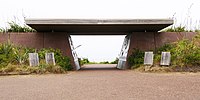
In order to demonstrate the importance of the place for the Māori to the visitors of the cape, an entrance gate was built at the entrance to the cape. As soon as a visitor reaches the entrance, mystical sounds are heard, which acoustically illustrate the transmigration of souls and are intended to make the place recognizable as a sacred place for visitors. On the way to the Cape Reinga Lighthouse , further information boards explain something about the mythology of the place and the surrounding nature.
Cape Reinga Lighthouse
The Cape Reinga Lighthouse was built in 1941, replacing the Cape Maria van Diemen Lighthouse , which was in operation around 7 km further west between 1879 and 1940. The lighthouse is fully automated today and is a tourist attraction at the Cape with a view of the vastness of the ocean. A sign in front of the lighthouse shows the distance of important geographic locations and cities.
Photo gallery
- Cape Reinga

Top of the cape
Entrance to the chap

Cape Reinga with lighthouse and Columbia Bank

.jpg)
_and_Columbia_Bank.jpg)
Web links
- Cape Reinga / Te Rerenga Wairua heritage . Depart of Conservation,accessed July 1, 2018.
Individual evidence
- ↑ a b Topo maps . Land Information New Zealand , accessed July 1, 2018 .
- ^ A b Ngāti Kuri and the Crown - Deed of Settlement of Historical Claims . (PDF 1.6 MB) Ngāti Kuri , p. 10 , accessed on July 1, 2018 (English).