Mount Noble
| Mount Noble | ||
|---|---|---|
|
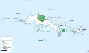
Map of Coronation Island with Mount Noble |
||
| height | 1165 m | |
| location | Coronation Island , South Orkney Islands | |
| Coordinates | 60 ° 39 ′ 0 ″ S , 45 ° 15 ′ 58 ″ W | |
|
|
||
Mount Noble is a 1,165 m high mountain in the eastern part of Coronation Island in the archipelago of the South Orkney Islands . It rises 3 km west of Gibbon Bay on the northern flank of the Roald Glacier .
The first sighting probably goes back to the US seal hunter captain Nathaniel Palmer and his British counterpart George Powell , who discovered the South Orkney Islands in December 1821. The British navigator James Weddell named it in 1823 after his friend, the orientalist James Noble († 1834) from Edinburgh .
Web links
- Mount Noble in the Geographic Names Information System of the United States Geological Survey (English)
- Mount Noble on geographic.org (English)

