Murewa

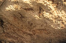
Murewa is a district capital in the province of Mashonaland East in Zimbabwe , 75 km east of the capital Harare , on the road to Tete in Mozambique . The altitude is slightly below 1400 m. With 8,398 inhabitants (2002 census) Murewa is the largest town in the district. But both public and private buildings are rather simple and give the place the character of a township. Nearby are the Murewa Caves and other rock overhangs and caves with Stone Age rock carvings of the San who once lived here , at least 1000 years old.
In recent years the Murewa Methodist Mission has set up an orphanage for AIDS orphans (Surviving Child Orphan Trust).
The Murewa district stretches over 120 km from the 1740 m high Mount Ahwa (10 km north of Macheke ) in the south to the Mazoe River in the north. The altitude of the valley is in the south and in the middle of the district at 1400 m, at Mazoe between 700 and 800 m. Hills with gentle slopes and witness mountains with steep rock faces rise above it.
The vast majority of residents are Shona . Three quarters of the area is defined by traditional African agriculture, the southern quarter by commercial farms. In the south there are also three small hill forts from the late phase of the ancient Zimbabwe culture ( Mutapa state ).
Web links
Maps
- Zimbabwe 1: 250,000, sheet Mutoko (topographic overview map, Surveyor General)
- Zimbabwe Land Classification, First Edition 1997 (Map 1: 1 000 000, Surveyor General)
Coordinates: 17 ° 39 ′ S , 31 ° 47 ′ E
