Myōgi-Arafune-Saku-Kōgen-Quasi-National Park
|
Myōgi-Arafune-Saku-Kōgen-Quasi-National Park
|
||
|
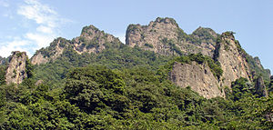
The mountain Myogi (1,104 m) in summer |
||
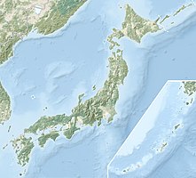
| location | Gunma Prefecture / Nagano Prefecture , Honshu , Japan | |
| surface | 131.23 km² | |
| WDPA ID | 3254 | |
| Geographical location | 36 ° 12 ' N , 138 ° 42' E | |
|
|
||
| Setup date | April 10, 1969 | |
| administration | Gunma Prefecture , Nagano Prefecture | |
The Myōgi-Arafune-Saku-Kōgen-Quasi-National Park ( Japanese 鳥 海 国 定 公園 , Chōkai kokutei kōen ) is one of more than 50 quasi-national parks in Japan . The park, founded on April 10, 1969, extends over an area of approx. 130 km² on the border of the two prefectures of Gunma and Nagano . Both prefectures are responsible for the administration of the quasi-national park. The park is named after the two mountains Myōgi (1,104 m) and Arafune (1,423 m). With the IUCN Category V, the park area is classified as a Protected Landscape / Protected Marine Area .
See also
Web links
Commons : Myōgi-Arafune-Saku-Kōgen-Quasi-National Park - Collection of pictures, videos and audio files

