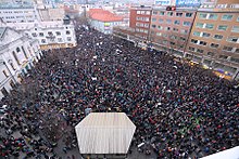
Námestie SNP (Bratislava)
Námestie SNP , short for Námestie Slovenského národného povstania (German place of the Slovak National Uprising ) is a place in the Slovak capital Bratislava . It is located northeast of the historic city center, between Steinplatz east and Hurban Square (intersection with Michalská and Obchodná streets) west of the square.
Important objects
In the upper part of the square, at the Nos. 4, we find the Calvinist Church (Slovak kalvínsky kostol ) in Neo-Romanesque style from 1913, the SNP monument in front of the church with three statues from the workshop of Slovak sculptor Ján Kulich from 1974. On the north-east side are the church and monastery of the Brothers of Mercy (Slovak Kostol a kláštor milosrdných bratov ) from the beginning of the 18th century. In the southwest corner is the old main post office (nos. 34 and 36) from 1912, the work of the architect Gyula Pártos . A few meters below you will find the building of the Tatra banka financial institute, which was completed in 1925 and is now the seat of the Slovak Ministry of Culture.
The functionalist building of the Dunaj department store (No. 30, Obchodný dom Dunaj in Slovak ) was built in 1936 within 90 days according to a project by the local architect Christian Ludwig. The old market hall ( Stará tržnica in Slovak ) from 1910 can be found on the east side. In front of the market hall are covered underground foundations of the medieval Jacob's chapel from the early 11th century. At the intersection with Štúrova Street, across from Steinplatz, is the 45-meter-high skyscraper (No. 23), which is known colloquially as Manderlák after the client, the entrepreneur Rudolf Manderla, and is considered the first skyscraper in Bratislava.
The square is set up as a “weak” pedestrian zone, with a continuous tram connection and limited motorized individual traffic.
Historical

The location of the current square was outside the historic city walls and was kept empty of permanent buildings for the purpose of effective defense. Therefore, the square was mainly used as a marketplace, where mainly traders outside the city stayed. In 1461 the square was mentioned as a bread market . At the beginning of the 18th century, the grain market moved here, and greengrocers, butchers, locksmiths, blacksmiths and stonemasons also had their place here. Several restaurants were built around the market square, one of which was called Escape in Egypt . However, the square area was divided between three different squares: the Barmherzigenplatz, the Tängerzeile and the Getreidemarkt. The grain market was called the poultry market or Grünerplatz since the late 18th century , after the predominant orientation of the local markets (vegetables, fruit, eggs and poultry). The Barmherzigenplatz was called Haynauplatz on a map from 1849–50 . In 1879 the three squares were united and the resulting square was officially named Marktplatz and was the venue for four annual fairs in the early 20th century.
During the First World War, the square was named after the German Emperor Wilhelm II. In 1921, shortly after the creation of Czechoslovakia , it was renamed Republic Square. It was later called Hlinka Square and 1949–1962 Stalin Square .
The square has had its current name since 1962.
The square was and is the scene of demonstrations, such as demonstrations during the Velvet Revolution in November 1989.
literature
- Tivadar Ortvay : Ulice a námestia Bratislavy - Ferdinandovo Mesto; Ferdinandstadt - Nándorváros. 2nd edition, Bratislava 2017, ISBN 978-80-8114-958-0 . (Pp. 38–56, keyword Námestie SNP (market square), Vásár tér); Hungarian original title: Pozsony város utcái és terei, published by Wigand, Pozsony 1905
Individual evidence
- ↑ a b Ján Lacika: Poznávame Slovensko - Bratislava . Dajama, Bratislava 2000, ISBN 80-88975-14-X , p. 150-153 (Slovak).
- ↑ Ortvay, p. 50
- ^ Ernst Hochberger: The big book of Slovakia , Sinn 2003, ISBN 3-921888-10-7 (p. 297)
- ↑ Ortvay, p. 40
Web links
Coordinates: 48 ° 8 ′ 43.7 ″ N , 17 ° 6 ′ 39.5 ″ E


