Narsapur
| Narsapur | ||
|---|---|---|
|
|
||
| State : |
|
|
| State : | Andhra Pradesh | |
| District : | West Godavari | |
| Location : | 16 ° 26 ' N , 81 ° 42' E | |
| Height : | 2 m | |
| Residents : | 58,770 (2011) | |
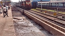
| Narsapur train station | ||
Narsapur , also Narasapur or Narasapuram , is a city in the Indian state of Andhra Pradesh . The city is named after Narasimha .
The city is part of the West Godavari district . Narsapur has the status of a municipality . The city is divided into 19 wards . It had a total of 58,770 inhabitants on the cut-off date of the 2011 census, of which 28,796 were men and 29,974 women. With a share of approx. 88%, Hindus form the largest group of the city's population, followed by Christians with approx. 6% and Muslims with approx. 4%. The literacy rate in 2011 was 86.24%.
The Dutch landed in Narsapur in 1626. The city was used as a port by the Dutch and was built to manufacture ships and boats. In the 16th century, the Portuguese founded their own factory, which served as a trading center for a few years. In the 18th century, Narsapur became an important trading port. However, its importance decreased over time. In the 19th century the city finally fell under the rule of the British.
The city is now connected to the rest of the country by a train station.

