Torotoro National Park
| Torotoro National Park | ||
|---|---|---|
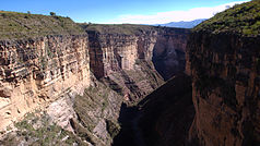
| Canyon in the Torotoro National Park | ||
|
|
||
| Location: | Potosí , Bolivia | |
| Next city: | Torotoro | |
| Surface: | 164 km² | |
| Founding: | July 26, 1989 | |
The Torotoro National Park (Spanish Parque Nacional Torotoro, Quechua Turu Turu mamallaqta parki ) is a small national park in Bolivia between the eastern mountain ranges of the South American Andes - Cordilleras with an area of 164 km².
geography
The national park is located in the northern Potosí Department around the town of Torotoro of the same name , 140 km south of Cochabamba and can only be reached via gravel roads and river beds, with a journey time of five to six hours in the dry season and considerably more in the rainy season , if the route sometimes even becomes impassable. The Torotoro National Park is located in a semi-arid landscape at an altitude of between 3,500 and 2,000 m, with extensive karst caves , such as the Humajalanta cave, and canyons that are cut up to 300 m deep.
fauna
In the park 49 species were recorded, including hippocamelus , Puma , Mountain Cat , Red-fronted Macaw , monk parakeet , Bolivian Blackbird ( Oreopsar bolivianus ) Brown Cap Erdhacker ( Upucerthia harterti ) and Iquicoschlüpfer ( Asthenes heterura ).
flora
There are still relics of the Quebracho forests, Podocarpus parlatorei , Schinopsis haenkeana , Cardenasiodendron brachypterum , Loxopterygium grisebachii , Amburana cearensis and Polylepis .

