Potosí Department
| Potosí Department P'utuqsi suyu P'utuqsi jach'a suyu Department de Potosí |
|||
|---|---|---|---|
| Symbols | |||
|
|||
| Basic data | |||
| Country | Bolivia | ||
| Capital | Potosí | ||
| surface | 118,218 km² | ||
| Residents | 823,517 (2012 census) | ||
| density | 7 inhabitants per km² | ||
| ISO 3166-2 | BO-P | ||
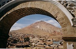
| The Potosí Silver Mountain | |||
Coordinates: 20 ° 40 ′ S , 66 ° 40 ′ W
The Potosí Department ( Quechua P'utuqsi suyu , Aymara P'utuqsi jach'a suyu , Spanish Departamento de Potosí ) is located in the southwest of Bolivia and has an area of 118,218 km², with a population of 823,517 (2012). It is mainly mountainous wasteland, with a wide plateau to the west. In this is the Salar de Uyuni , the largest salt lake in the world. Potosi borders in the northwest to the Oruro Department , on the north by the department of Cochabamba , on the east by the Chuquisaca , in the southeast on the Tarija Department , on the south by Argentina and on the west by Chile .
population
The population of the department has increased by more than half over the past sixty years:
| year | Residents | source |
|---|---|---|
| 1950 | 509 087 | census |
| 1976 | 657 743 | census |
| 1992 | 645 889 | census |
| 2001 | 709 013 | census |
| 2012 | 823 517 | census |
Due to the historical population distribution, the Potosí Department has a high proportion of Quechua population; of the population over 6 years old, 78.3 percent speak the Quechua language . ( 2001 )
Provinces
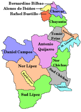
The Potosí Department is divided into sixteen provinces (population figures: 2001 census → 2012 census):
- Alonso de Ibáñez Province (27,755 → 27,970)
- Antonio Quijarro Province (37,428 → 54,947)
- Bernardino Province Bilbao (10,623 → 10,224)
- Charcas Province (38,174 → 41,214)
- Chayanta Province (90,205 → 97,251)
- Province of Cornelio Saavedra (58,706 → 55,100)
- Daniel Campos Province (5,067 → 5,850)
- Province of Enrique Baldivieso (1,640 → 1,684) (also: Enrique Valdivieso )
- José María Linares Province (51,412 → 49,619)
- Modesto Omiste Province (36,266 → 44,645)
- Nor Chichas Province (35,323 → 42,248)
- Nor Lípez Province (10,460 → 14,057)
- Rafael Bustillo Province (76,254 → 86,947)
- Province of Sur Chichas (47.873 → 55.879) (also: Sud Chichas )
- Province of Sur Lípez (4,905 → 6,835) (also: Sud Lípez )
- Tomás Frías Province (176.922 → 229.047) (includes the city of Potosí )
Cities
The capital and largest city is Potosí , other important cities are the border town with Argentina , Villazón , as well as Tupiza , Llallagua and Uyuni .
| city | Population 2001 (census) |
Population 2012 (census) |
|---|---|---|
| Potosí | 132,966 | 174,973 |
| Villazón | 28,045 | 35,167 |
| Tupiza | 21,707 | 27.302 |
| Llallagua | 20,065 | 25.166 |
| Uyuni | 10,551 | 18,068 |
politics
Overall result of the regional elections on April 4, 2010 in the Potosí Department:
| electoral legitimate |
electoral participation |
valid votes | MAS-IPSP | AS | ACU | FCRP | MNR | ||
|---|---|---|---|---|---|---|---|---|---|
| 367.149 | 305,362 | 245,452 | 163.989 | 31,564 | 27,873 | 15,960 | 6,066 | ||
| 83.2% | 80.4% | 66.8% | 12.9% | 11.4% | 6.5% | 2.5% |
Web links
- Information about the department on the website of the Bolivian Embassy in Berlin
Individual evidence
- ↑ a b c d Instituto Nacional de Estadística (INE) ( Memento of the original from February 26, 2014 in the Internet Archive ) Info: The archive link has been inserted automatically and has not yet been checked. Please check the original and archive link according to the instructions and then remove this notice.
- ↑ INE - Instituto Nacional de Estadística Bolivia 2012 ( Memento of the original from March 4, 2016 in the Internet Archive ) Info: The archive link was inserted automatically and has not yet been checked. Please check the original and archive link according to the instructions and then remove this notice.
- ↑ GEOHive according to: Instituto Nacional de Estadística Bolivia (INE) 2013
- ↑ Acta de computo Nacional Electoral Departamentales, Municipales y Regional 2010


